Geographic Region: ARGENTINA
Feature: LIMAY RIVER, LAKE
|
Geographic Region: ARGENTINA Feature: LIMAY RIVER, LAKE |
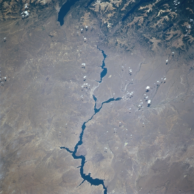 |
| STS081-728-083 Rio Limay, Argentina January 1997 The varying width of the Limay and Collon Cura Rivers (dark, linear features) create substantial reservoirs, constructed to produce hydroelectric power for Argentina. The water in these reservoirs provides a dramatic color contrast with the sparsely vegetated, arid terrain of the rugged plateau of Patagonia in southern Argentina. Two glacially formed lakes (dark features, top) are visible within valleys on the eastern flank of the Andes Mountains (top). The larger, southern lake is Lago Nahuel Huapi and the narrow northern lake is Lago Traful. These lakes and numerous smaller lakes within the Andes Mountains provide snow and ice runoff that feeds the rivers and streams along the eastern front of the Andes Mountains. This section of the northeasterly flowing Rio Limay forms the border between Neuquen Province (north of the river) and northwest Rio Negro Province (south of the river). The south flowing Rio Collon Cura is seen merging with the Rio Limay near the center of the image. |
| Images: | All Available Images Low-Resolution 340k |
|
| Mission: | STS081 |
|
| Roll - Frame: | 728 - 83 |
|
| Geographical Name: | ARGENTINA |
|
| Features: | LIMAY RIVER, LAKE |
|
| Center Lat x Lon: | 41S x 70W |
|
| Film Exposure: | N | N=Normal exposure, U=Under exposed, O=Over exposed, F=out of Focus |
| Percentage of Cloud Cover-CLDP: | 0 |
|
| Camera:: | HB |
|
| Camera Tilt: | 45 | LO=Low Oblique, HO=High Oblique, NV=Near Vertical |
| Camera Focal Length: | 250 |
|
| Nadir to Photo Center Direction: | S | The direction from the nadir to the center point, N=North, S=South, E=East, W=West |
| Stereo?: | Y | Y=Yes there is an adjacent picture of the same area, N=No there isn't |
| Orbit Number: | 132 |
|
| Date: | 19970120 | YYYYMMDD |
| Time: | 181336 | GMT HHMMSS |
| Nadir Lat: | 37.8S |
Latitude of suborbital point of spacecraft |
| Nadir Lon: | 68.7W |
Longitude of suborbital point of spacecraft |
| Sun Azimuth: | 307 | Clockwise angle in degrees from north to the sun measured at the nadir point |
| Space Craft Altitude: | 205 | nautical miles |
| Sun Elevation: | 64 | Angle in degrees between the horizon and the sun, measured at the nadir point |
| Land Views: | MOUNTAIN, PLATEAU |
|
| Water Views: | LAKE, RESERVOIR |
|
| Atmosphere Views: | |
|
| Man Made Views: | |
|
| City Views: | |
|
Photo is not associated with any sequences | ||
| NASA Home Page |
JSC Home Page |
JSC Digital Image Collection |
Earth Science & Remote Sensing |
|
This service is provided by the International Space Station program and the JSC Earth Science & Remote Sensing Unit, ARES Division, Exploration Integration Science Directorate.

|