
Geographic Region: EL SALVADOR
Feature: SAN SALVADOR, VOLCANO
|
Geographic Region: EL SALVADOR Feature: SAN SALVADOR, VOLCANO |
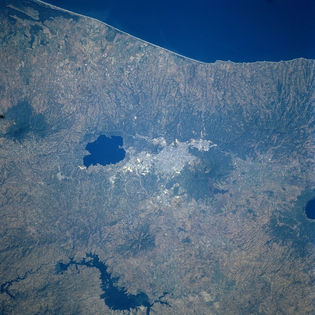 |
| STS081-728-057 San Salvador, El Salvador January 1997 The capital city of El Salvador, San Salvador, can be seen near the center of the image in this south-looking view. San Salvador is located in a valley at 2100 feet (640 meters) on the eastern flank of San Salvador Volcano. Near the eastern end of the city and visible on the image is the caldera of the Ilopango Volcano, now a deep lake. The city of San Salvador is located 20 miles (32 km) north of the coast of the Pacific Ocean (top of image). An important industrial center, San Salvador has factories producing soap, silk, and cotton textiles, cigars, sugar, and beer. San Salvador also has the distinction of having the largest shopping mall in Central America. The city is built on a modified gridiron pattern with wide streets and many parks. Due to the threat of earthquakes, the city's houses tend to be low and surrounded by open areas. Earthquakes, ranging from 6.5 to 7.9 on the Richter scale, have struck San Salvador 13 times over the last 400 years all but destroying the city in 1854, 1873, 1917, and most recently in October of 1986. The 1986 earthquake killed 1400 people, injured 21,000, and left nearly 300,000 homeless. Of the volcanoes located within the metropolitan area, San Salvador Volcano last erupted in 1917 and Ilopango Volcano last erupted in 1879. Near the bottom center of the image, the new Cerron Grande Reservoir is visible. Near the right center of the image, the deep lake caldera of Coatepeque Volcano is visible. |
| Images: | All Available Images Low-Resolution 389k |
|
| Mission: | STS081 |
|
| Roll - Frame: | 728 - 57 |
|
| Geographical Name: | EL SALVADOR |
|
| Features: | SAN SALVADOR, VOLCANO |
|
| Center Lat x Lon: | 14.0N x 89W |
|
| Film Exposure: | N | N=Normal exposure, U=Under exposed, O=Over exposed, F=out of Focus |
| Percentage of Cloud Cover-CLDP: | 0 |
|
| Camera:: | HB |
|
| Camera Tilt: | 22 | LO=Low Oblique, HO=High Oblique, NV=Near Vertical |
| Camera Focal Length: | 250 |
|
| Nadir to Photo Center Direction: | N | The direction from the nadir to the center point, N=North, S=South, E=East, W=West |
| Stereo?: | Y | Y=Yes there is an adjacent picture of the same area, N=No there isn't |
| Orbit Number: | 131 |
|
| Date: | 19970120 | YYYYMMDD |
| Time: | 162441 | GMT HHMMSS |
| Nadir Lat: | 12.7N |
Latitude of suborbital point of spacecraft |
| Nadir Lon: | 88.9W |
Longitude of suborbital point of spacecraft |
| Sun Azimuth: | 142 | Clockwise angle in degrees from north to the sun measured at the nadir point |
| Space Craft Altitude: | 192 | nautical miles |
| Sun Elevation: | 49 | Angle in degrees between the horizon and the sun, measured at the nadir point |
| Land Views: | VOLCANO, CRATER, FAULT |
|
| Water Views: | LAKE |
|
| Atmosphere Views: | |
|
| Man Made Views: | URBAN AREA |
|
| City Views: | SAN SALVADOR |
|
Photo is not associated with any sequences | ||
| NASA Home Page |
JSC Home Page |
JSC Digital Image Collection |
Earth Science & Remote Sensing |
|
This service is provided by the International Space Station program and the JSC Earth Science & Remote Sensing Unit, ARES Division, Exploration Integration Science Directorate.

|