Geographic Region: CHILE
Feature: GULF OF CORCOVADO
|
Geographic Region: CHILE Feature: GULF OF CORCOVADO |
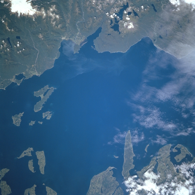 |
| STS081-724-083 Gulf of Corcovado, Chile January 1997 The northern Gulf of Corcovado can be seen in this west-northwest-looking view. An inlet of the Pacific Ocean, the gulf separates the island of Chiloe (upper left), the largest of the Chilean Islands, from the Chilean mainland (bottom). Islands discernible along the right center and upper right separate the Gulf of Corcovado from the Gulf of Ancud (not visible). Lumbering, fishing, and tourism are the main industries of the small surrounding communities. The snow-capped mountain seen on the lower-left margin of the image, with three lakes on its north and northeast flanks, is the 7000 foot (2135 meter) Corcovado Volcano. The pointed island protruding into the gulf in the upper left portion of the image is Tranqui Island. |
| Images: | All Available Images Low-Resolution 300k |
|
| Mission: | STS081 |
|
| Roll - Frame: | 724 - 83 |
|
| Geographical Name: | CHILE |
|
| Features: | GULF OF CORCOVADO |
|
| Center Lat x Lon: | 43S x 73W |
|
| Film Exposure: | N | N=Normal exposure, U=Under exposed, O=Over exposed, F=out of Focus |
| Percentage of Cloud Cover-CLDP: | 5 |
|
| Camera:: | HB |
|
| Camera Tilt: | LO=Low Oblique, HO=High Oblique, NV=Near Vertical |
|
| Camera Focal Length: | 250 |
|
| Nadir to Photo Center Direction: | The direction from the nadir to the center point, N=North, S=South, E=East, W=West |
|
| Stereo?: | Y | Y=Yes there is an adjacent picture of the same area, N=No there isn't |
| Orbit Number: | |
|
| Date: | 199701__ | YYYYMMDD |
| Time: | GMT HHMMSS |
|
| Nadir Lat: | N |
Latitude of suborbital point of spacecraft |
| Nadir Lon: | E |
Longitude of suborbital point of spacecraft |
| Sun Azimuth: | Clockwise angle in degrees from north to the sun measured at the nadir point |
|
| Space Craft Altitude: | nautical miles |
|
| Sun Elevation: | Angle in degrees between the horizon and the sun, measured at the nadir point |
|
| Land Views: | ISLAND, FOREST, VOLCANO |
|
| Water Views: | GULF |
|
| Atmosphere Views: | |
|
| Man Made Views: | |
|
| City Views: | |
|
Photo is not associated with any sequences | ||
| NASA Home Page |
JSC Home Page |
JSC Digital Image Collection |
Earth Science & Remote Sensing |
|
This service is provided by the International Space Station program and the JSC Earth Science & Remote Sensing Unit, ARES Division, Exploration Integration Science Directorate.

|