
Geographic Region: ARGENTINA
Feature: MOUTH OF RIO NEGRO
|
Geographic Region: ARGENTINA Feature: MOUTH OF RIO NEGRO |
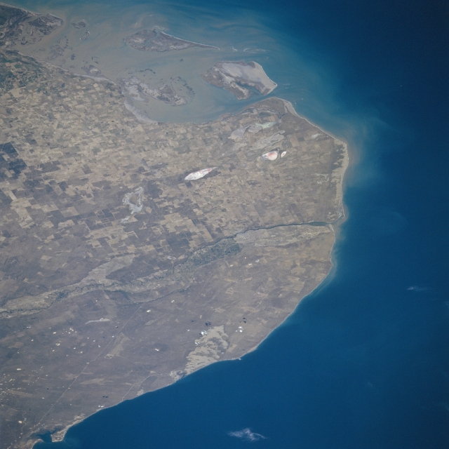 |
| STS081-724-066 The Rio Negro, Argentina January 1997 Situated between Point Rasa to the east and Point Bermeja to the west, lies the mouth of the Rio Negro (midway between the center and right center of the image). The Rio Negro, 400 miles (645 km) long, is formed in central Argentina by the confluence of the Neuquen and Limay Rivers (not visible on the image) and flows generally eastward to the Atlantic Ocean. The river is used extensively for irrigation due to its location in the extreme southern pampas agricultural area of Argentina. As seen on the image, little sediment from the waters of the Rio Negro reaches its Atlantic Ocean mouth. At the upper left and upper center of the image, sediment from the Colorado River mouth is visible. Along the bottom left to bottom center, the waters of the northern portions of San Matias Gulf can be seen. |
| Images: | All Available Images Low-Resolution 277k |
|
| Mission: | STS081 |
|
| Roll - Frame: | 724 - 66 |
|
| Geographical Name: | ARGENTINA |
|
| Features: | MOUTH OF RIO NEGRO |
|
| Center Lat x Lon: | 40.5S x 64W |
|
| Film Exposure: | N | N=Normal exposure, U=Under exposed, O=Over exposed, F=out of Focus |
| Percentage of Cloud Cover-CLDP: | 0 |
|
| Camera:: | HB |
|
| Camera Tilt: | LO=Low Oblique, HO=High Oblique, NV=Near Vertical |
|
| Camera Focal Length: | 250 |
|
| Nadir to Photo Center Direction: | The direction from the nadir to the center point, N=North, S=South, E=East, W=West |
|
| Stereo?: | Y | Y=Yes there is an adjacent picture of the same area, N=No there isn't |
| Orbit Number: | |
|
| Date: | 199701__ | YYYYMMDD |
| Time: | GMT HHMMSS |
|
| Nadir Lat: | N |
Latitude of suborbital point of spacecraft |
| Nadir Lon: | E |
Longitude of suborbital point of spacecraft |
| Sun Azimuth: | Clockwise angle in degrees from north to the sun measured at the nadir point |
|
| Space Craft Altitude: | nautical miles |
|
| Sun Elevation: | Angle in degrees between the horizon and the sun, measured at the nadir point |
|
| Land Views: | COAST, PLAIN |
|
| Water Views: | RIVER, SEDIMENT |
|
| Atmosphere Views: | |
|
| Man Made Views: | AGRICULTURE |
|
| City Views: | |
|
Photo is not associated with any sequences | ||
| NASA Home Page |
JSC Home Page |
JSC Digital Image Collection |
Earth Science & Remote Sensing |
|
This service is provided by the International Space Station program and the JSC Earth Science & Remote Sensing Unit, ARES Division, Exploration Integration Science Directorate.

|