
Geographic Region: MEXICO
Feature: BAJA, MAGDALENA ISLAND
|
Geographic Region: MEXICO Feature: BAJA, MAGDALENA ISLAND |
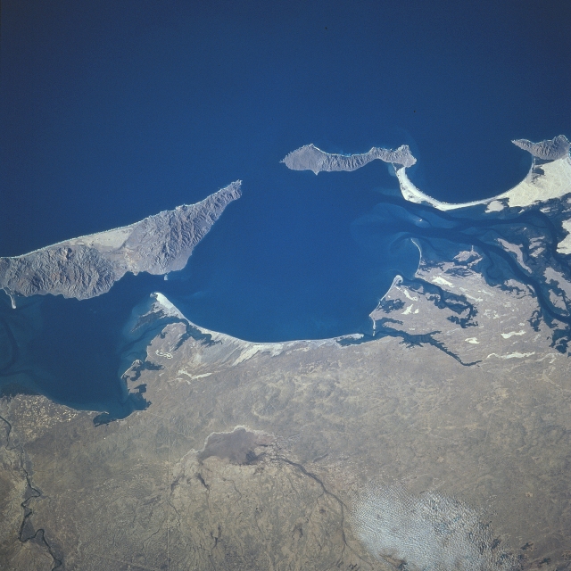 |
| STS081-724-024 Magdalena Bay, Santa Margarita Island, Mexico January 1997 Magdalena Bay, an inlet of the Pacific Ocean, can be seen in this south-looking view. Located on the Pacific Ocean in southwestern Baja California, the rather narrow Magdalena Bay is the winter home to some of the largest animals on Earth. At the end of their 5000 mile (5650 km) journey from the Bering Sea between Russia and Alaska, thousands of gray whales congregate each year in the protected bay waters to mate, bear their young, and pass the winter months before returning to the Bering Sea in the Spring. The bay is also home to sea lions, dolphins, and other types of large whales. Magdalena Bay is located in a semi-arid wilderness surrounded by rugged islands, uninhabited beaches, sand dunes, and mangrove channels. Thousands of tourists visit this region each winter to observe the large numbers of animals congregating in and around the bay. Near the left center of the image, the small, but rugged island of Santa Margarita can be seen. |
| Images: | All Available Images Low-Resolution 311k |
|
| Mission: | STS081 |
|
| Roll - Frame: | 724 - 24 |
|
| Geographical Name: | MEXICO |
|
| Features: | BAJA, MAGDALENA ISLAND |
|
| Center Lat x Lon: | 25.0N x 112W |
|
| Film Exposure: | N | N=Normal exposure, U=Under exposed, O=Over exposed, F=out of Focus |
| Percentage of Cloud Cover-CLDP: | 0 |
|
| Camera:: | HB |
|
| Camera Tilt: | LO=Low Oblique, HO=High Oblique, NV=Near Vertical |
|
| Camera Focal Length: | 250 |
|
| Nadir to Photo Center Direction: | The direction from the nadir to the center point, N=North, S=South, E=East, W=West |
|
| Stereo?: | Y | Y=Yes there is an adjacent picture of the same area, N=No there isn't |
| Orbit Number: | |
|
| Date: | 199701__ | YYYYMMDD |
| Time: | GMT HHMMSS |
|
| Nadir Lat: | N |
Latitude of suborbital point of spacecraft |
| Nadir Lon: | E |
Longitude of suborbital point of spacecraft |
| Sun Azimuth: | Clockwise angle in degrees from north to the sun measured at the nadir point |
|
| Space Craft Altitude: | nautical miles |
|
| Sun Elevation: | Angle in degrees between the horizon and the sun, measured at the nadir point |
|
| Land Views: | ISLAND, DESERT, COAST, HILL |
|
| Water Views: | BAY, PLAYA |
|
| Atmosphere Views: | |
|
| Man Made Views: | |
|
| City Views: | |
|
Photo is not associated with any sequences | ||
| NASA Home Page |
JSC Home Page |
JSC Digital Image Collection |
Earth Science & Remote Sensing |
|
This service is provided by the International Space Station program and the JSC Earth Science & Remote Sensing Unit, ARES Division, Exploration Integration Science Directorate.

|