Geographic Region: MEXICO
Feature: LAGOON SAN IGNACIO
|
Geographic Region: MEXICO Feature: LAGOON SAN IGNACIO |
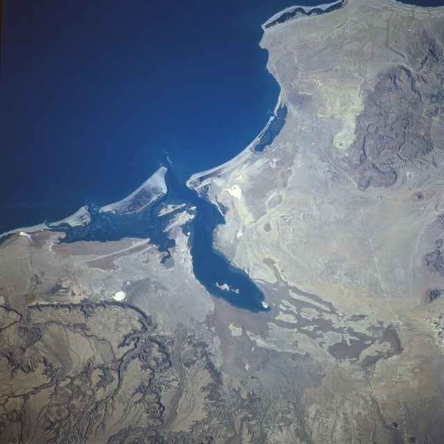 |
| STS081-724-022 Laguna San Ignacio, Baja California, Mexico January 1997 The dark, finger-like protrusion of the Pacific Ocean that extends into the southwest coast of Baja California is called Laguna San Ignacio. Laguna San Ignacio is one of several breeding lagoons that gray whales use along the west coast of Baja California. Smaller estuaries (dark features) that parallel the coast are also visible. The flat, highly reflective terrain immediately west of the large lagoon has been converted into an area where salt ponds have been established for the commercial production of salt. Seawater is pumped through a series of gravity fed ponds thereby increasing the salt content through a natural evaporation process. The deeply eroded plateau structures northwest and especially southeast of the Laguna San Ignacio are part of a series of volcanic erosional surfaces that have formed along the west coast of Baja California. The single, narrow, light colored line is a road that connects the coastal area with the other parts of Baja California. |
| Images: | All Available Images Low-Resolution 332k |
|
| Mission: | STS081 |
|
| Roll - Frame: | 724 - 22 |
|
| Geographical Name: | MEXICO |
|
| Features: | LAGOON SAN IGNACIO |
|
| Center Lat x Lon: | 27.0N x 113W |
|
| Film Exposure: | N | N=Normal exposure, U=Under exposed, O=Over exposed, F=out of Focus |
| Percentage of Cloud Cover-CLDP: | 0 |
|
| Camera:: | HB |
|
| Camera Tilt: | LO=Low Oblique, HO=High Oblique, NV=Near Vertical |
|
| Camera Focal Length: | 250 |
|
| Nadir to Photo Center Direction: | The direction from the nadir to the center point, N=North, S=South, E=East, W=West |
|
| Stereo?: | N | Y=Yes there is an adjacent picture of the same area, N=No there isn't |
| Orbit Number: | |
|
| Date: | 199701__ | YYYYMMDD |
| Time: | GMT HHMMSS |
|
| Nadir Lat: | N |
Latitude of suborbital point of spacecraft |
| Nadir Lon: | E |
Longitude of suborbital point of spacecraft |
| Sun Azimuth: | Clockwise angle in degrees from north to the sun measured at the nadir point |
|
| Space Craft Altitude: | nautical miles |
|
| Sun Elevation: | Angle in degrees between the horizon and the sun, measured at the nadir point |
|
| Land Views: | COAST |
|
| Water Views: | BAY, ESTUARY |
|
| Atmosphere Views: | |
|
| Man Made Views: | HIGHWAY |
|
| City Views: | |
|
Photo is not associated with any sequences | ||
| NASA Home Page |
JSC Home Page |
JSC Digital Image Collection |
Earth Science & Remote Sensing |
|
This service is provided by the International Space Station program and the JSC Earth Science & Remote Sensing Unit, ARES Division, Exploration Integration Science Directorate.

|