
Geographic Region: ITALY
Feature: L. BOLSENA, L. BRACCIANO
|
Geographic Region: ITALY Feature: L. BOLSENA, L. BRACCIANO |
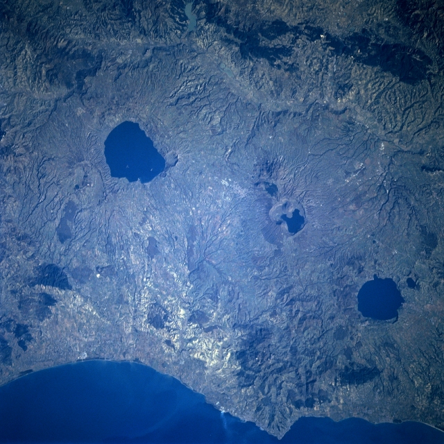 |
| STS081-717-073 Lake Bolsena, Lake Bracciano, Italy January 1997 The three, generally oval-shaped, dark features are lakes that have formed in collapsed craters (calderas) of volcanoes. From northwest to southeast these lakes are Lake Bolsena, Lake diVico (small lake), and Lake Bracciano. The lakes are located northwest of Rome, along the east coast of central Italy. Sizeable lava flows are visible radiating outward from each of the water-filled calderas. The two large lakes drain southwest into the Tyrrhenian Sea. A narrow valley, aligned northwest to southeast provides routing access for a railroad, a highway, and the Tiber River along the eastern base of the volcanic structures. The dark feature (narrow swath) near the top of the image appears to be some type of dense vegetation, perhaps forested land, that follows the higher elevations on the east side of the Tiber River Valley. |
| Images: | All Available Images Low-Resolution 373k |
|
| Mission: | STS081 |
|
| Roll - Frame: | 717 - 73 |
|
| Geographical Name: | ITALY |
|
| Features: | L. BOLSENA, L. BRACCIANO |
|
| Center Lat x Lon: | 43.0N x 12.0E |
|
| Film Exposure: | N | N=Normal exposure, U=Under exposed, O=Over exposed, F=out of Focus |
| Percentage of Cloud Cover-CLDP: | 0 |
|
| Camera:: | HB |
|
| Camera Tilt: | 32 | LO=Low Oblique, HO=High Oblique, NV=Near Vertical |
| Camera Focal Length: | 250 |
|
| Nadir to Photo Center Direction: | NW | The direction from the nadir to the center point, N=North, S=South, E=East, W=West |
| Stereo?: | N | Y=Yes there is an adjacent picture of the same area, N=No there isn't |
| Orbit Number: | 33 |
|
| Date: | 19970114 | YYYYMMDD |
| Time: | 094842 | GMT HHMMSS |
| Nadir Lat: | 41.7N |
Latitude of suborbital point of spacecraft |
| Nadir Lon: | 13.6E |
Longitude of suborbital point of spacecraft |
| Sun Azimuth: | 158 | Clockwise angle in degrees from north to the sun measured at the nadir point |
| Space Craft Altitude: | 195 | nautical miles |
| Sun Elevation: | 24 | Angle in degrees between the horizon and the sun, measured at the nadir point |
| Land Views: | VOLCANO, CALDERA |
|
| Water Views: | LAKE |
|
| Atmosphere Views: | |
|
| Man Made Views: | |
|
| City Views: | |
|
Photo is not associated with any sequences | ||
| NASA Home Page |
JSC Home Page |
JSC Digital Image Collection |
Earth Science & Remote Sensing |
|
This service is provided by the International Space Station program and the JSC Earth Science & Remote Sensing Unit, ARES Division, Exploration Integration Science Directorate.

|