
Geographic Region: ITALY
Feature: LAKE GARDA, MOUNTAINS
|
Geographic Region: ITALY Feature: LAKE GARDA, MOUNTAINS |
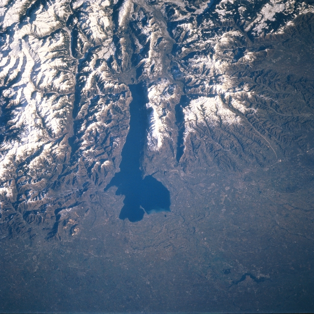 |
| STS081-717-066 Lake Garda, Italy January 1997 Lake Garda, the elongated, dark feature near the center of the picture, is one of several glacially formed lakes in the Italian Alps of northern Italy. Lake Garda occupies a basin where the southern extent of an Alpine valley was deepened by glaciers and dammed by a large terminal moraine. The lake is 32 miles (51 km) long and has contrasting scenery that includes open, rolling plains at the southern end and rugged, precipitous mountains east and west of the lake. The paralleling valleys adjacent to Lake Garda show elongated, dark features, which are shadows caused by the high, snow covered mountains. There is, however, a small lake (dark feature) in the valley immediately west of Lake Garda. The Italian cities of Verona (southeast of the lake) and Brescia (southwest of the lake) are in this scene but cannot be identified because of the small scale of the image and the lack of contrast between the natural environment and the urban areas. The bottom third of the image shows a section of the broad alluvial plains of the Po River Valley. |
| Images: | All Available Images Low-Resolution 398k |
|
| Mission: | STS081 |
|
| Roll - Frame: | 717 - 66 |
|
| Geographical Name: | ITALY |
|
| Features: | LAKE GARDA, MOUNTAINS |
|
| Center Lat x Lon: | 45.5N x 10.5E |
|
| Film Exposure: | N | N=Normal exposure, U=Under exposed, O=Over exposed, F=out of Focus |
| Percentage of Cloud Cover-CLDP: | 0 |
|
| Camera:: | HB |
|
| Camera Tilt: | 32 | LO=Low Oblique, HO=High Oblique, NV=Near Vertical |
| Camera Focal Length: | 250 |
|
| Nadir to Photo Center Direction: | N | The direction from the nadir to the center point, N=North, S=South, E=East, W=West |
| Stereo?: | N | Y=Yes there is an adjacent picture of the same area, N=No there isn't |
| Orbit Number: | 33 |
|
| Date: | 19970114 | YYYYMMDD |
| Time: | 094749 | GMT HHMMSS |
| Nadir Lat: | 43.6N |
Latitude of suborbital point of spacecraft |
| Nadir Lon: | 9.8E |
Longitude of suborbital point of spacecraft |
| Sun Azimuth: | 155 | Clockwise angle in degrees from north to the sun measured at the nadir point |
| Space Craft Altitude: | 193 | nautical miles |
| Sun Elevation: | 21 | Angle in degrees between the horizon and the sun, measured at the nadir point |
| Land Views: | MOUNTAIN, PLAIN, VALLEY |
|
| Water Views: | LAKE |
|
| Atmosphere Views: | |
|
| Man Made Views: | |
|
| City Views: | |
|
Photo is not associated with any sequences | ||
| NASA Home Page |
JSC Home Page |
JSC Digital Image Collection |
Earth Science & Remote Sensing |
|
This service is provided by the International Space Station program and the JSC Earth Science & Remote Sensing Unit, ARES Division, Exploration Integration Science Directorate.

|