Geographic Region: ARGENTINA
Feature: PATAGONIA, MUSTERS LAKE
|
Geographic Region: ARGENTINA Feature: PATAGONIA, MUSTERS LAKE |
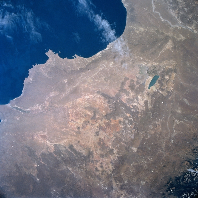 |
| STS081-711-073 Musters Lake, Chubut River, Argentina January 1997 With Saint George Gulf in the upper center of this view the east-central area of Patagonia is visible. Patagonia is a harsh windswept high semi-arid plateau with scanty vegetation, which slopes gently eastward from the high Andes Mountains in the west, and terminates in cliffs along the Atlantic Ocean coast. The Catarce Del Bajo and Montemayor Uplands are discernible along the coast midway from the center to the top center of the image. Just to the right (west) of the center of the image is blue Musters Lake. Look carefully just to the left (east) of Muster for the very shallow, highly sediment-laden Cohue Huapi Lake which nearly matches the color of the surrounding land. Just west of Muster Lake are the San Bernardo Hills. The mouth of the Chubut River can be seen near the far left center of the image. The Chubut River rises in the Andes Mountains of western Argentina and flows generally eastward to the Atlantic Ocean near the town of Rawson. Sheep herding and fruit growing are important along the Chubut River's lower course. |
| Images: | All Available Images Low-Resolution 330k |
|
| Mission: | STS081 |
|
| Roll - Frame: | 711 - 73 |
|
| Geographical Name: | ARGENTINA |
|
| Features: | PATAGONIA, MUSTERS LAKE |
|
| Center Lat x Lon: | 44.5S x 69W |
|
| Film Exposure: | N | N=Normal exposure, U=Under exposed, O=Over exposed, F=out of Focus |
| Percentage of Cloud Cover-CLDP: | 5 |
|
| Camera:: | HB |
|
| Camera Tilt: | 16 | LO=Low Oblique, HO=High Oblique, NV=Near Vertical |
| Camera Focal Length: | 40 |
|
| Nadir to Photo Center Direction: | NW | The direction from the nadir to the center point, N=North, S=South, E=East, W=West |
| Stereo?: | Y | Y=Yes there is an adjacent picture of the same area, N=No there isn't |
| Orbit Number: | 148 |
|
| Date: | 19970121 | YYYYMMDD |
| Time: | 184419 | GMT HHMMSS |
| Nadir Lat: | 45.1S |
Latitude of suborbital point of spacecraft |
| Nadir Lon: | 68.2W |
Longitude of suborbital point of spacecraft |
| Sun Azimuth: | 306 | Clockwise angle in degrees from north to the sun measured at the nadir point |
| Space Craft Altitude: | 206 | nautical miles |
| Sun Elevation: | 55 | Angle in degrees between the horizon and the sun, measured at the nadir point |
| Land Views: | PLATEAU, COAST, HILL |
|
| Water Views: | LAKE, RIVER |
|
| Atmosphere Views: | |
|
| Man Made Views: | |
|
| City Views: | |
|
Photo is not associated with any sequences | ||
| NASA Home Page |
JSC Home Page |
JSC Digital Image Collection |
Earth Science & Remote Sensing |
|
This service is provided by the International Space Station program and the JSC Earth Science & Remote Sensing Unit, ARES Division, Exploration Integration Science Directorate.

|