
Geographic Region: CHINA
Feature: ER L.,DALI,DIANCANG MTS.
|
Geographic Region: CHINA Feature: ER L.,DALI,DIANCANG MTS. |
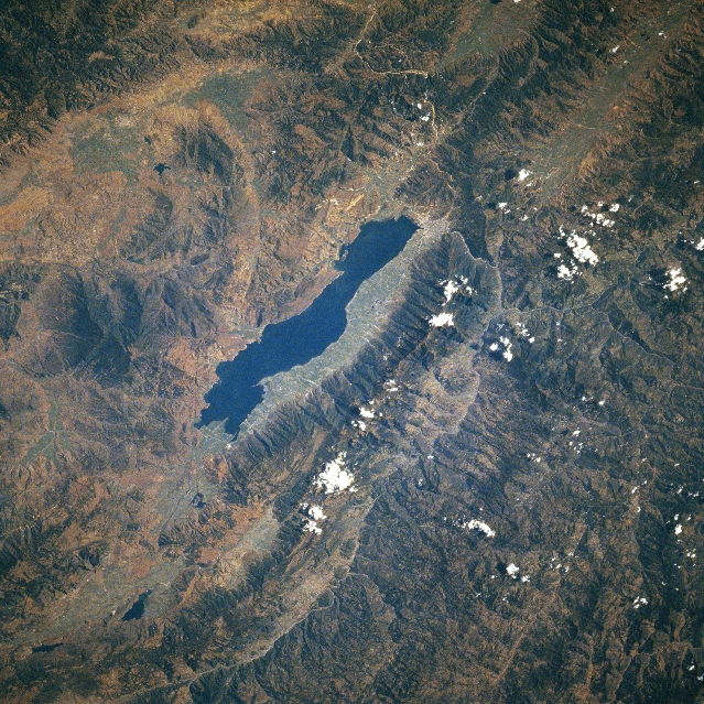 |
| STS080-748-078 Lake Er Area, China November 1996 Located in southwest China in northern Yunnan Province, the southern extent of the rugged Yun Mountains surround Lake Er (elongated dark feature center of image). Typically the local relief between the valley floors and mountain ridgelines is about 5000 feet (1525 meters). Most of the mountain ridgelines in this region of the Yun Mountains are in excess of 12000 feet (3660 meters) above sea level. Near the south end of Lake Er a highway (thin, light-colored line, top center) can be traced through the narrow, mountainous valleys that connect the city of Xiaguan (visible at southwest corner of the lake) with cities to the east (including Kunming the capital of Yunnan Province but not on this image). Rice is the predominant crop grown in the mountain valleys. |
| Images: | All Available Images Low-Resolution 432k |
|
| Mission: | STS080 |
|
| Roll - Frame: | 748 - 78 |
|
| Geographical Name: | CHINA |
|
| Features: | ER L.,DALI,DIANCANG MTS. |
|
| Center Lat x Lon: | 26.0N x 100.0E |
|
| Film Exposure: | N | N=Normal exposure, U=Under exposed, O=Over exposed, F=out of Focus |
| Percentage of Cloud Cover-CLDP: | 5 |
|
| Camera:: | HB |
|
| Camera Tilt: | 39 | LO=Low Oblique, HO=High Oblique, NV=Near Vertical |
| Camera Focal Length: | 250 |
|
| Nadir to Photo Center Direction: | W | The direction from the nadir to the center point, N=North, S=South, E=East, W=West |
| Stereo?: | N | Y=Yes there is an adjacent picture of the same area, N=No there isn't |
| Orbit Number: | 133 |
|
| Date: | 19961128 | YYYYMMDD |
| Time: | 051207 | GMT HHMMSS |
| Nadir Lat: | 25.2N |
Latitude of suborbital point of spacecraft |
| Nadir Lon: | 102.4E |
Longitude of suborbital point of spacecraft |
| Sun Azimuth: | 184 | Clockwise angle in degrees from north to the sun measured at the nadir point |
| Space Craft Altitude: | 189 | nautical miles |
| Sun Elevation: | 43 | Angle in degrees between the horizon and the sun, measured at the nadir point |
| Land Views: | MOUNTAIN |
|
| Water Views: | LAKE |
|
| Atmosphere Views: | |
|
| Man Made Views: | |
|
| City Views: | |
|
Photo is not associated with any sequences | ||
| NASA Home Page |
JSC Home Page |
JSC Digital Image Collection |
Earth Science & Remote Sensing |
|
This service is provided by the International Space Station program and the JSC Earth Science & Remote Sensing Unit, ARES Division, Exploration Integration Science Directorate.

|