
Geographic Region: INDIA
Feature: BRAHMAPUTRA R.,DEFOREST.
|
Geographic Region: INDIA Feature: BRAHMAPUTRA R.,DEFOREST. |
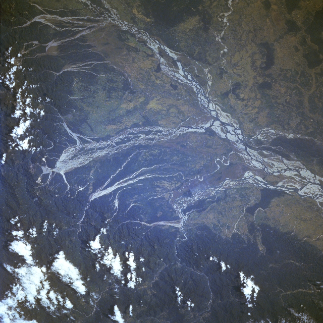 |
| STS080-748-075 Brahmaputra River, India November 1996 The Brahmaputra River of northeast India is considered both destructive and beneficial to northeast India and Bangladesh. The river is destructive because on an annual basis, the wet summer monsoon that affects south Asia causes disastrous and frequent floods in the region. The river is beneficial because it carries rich soils that it deposits on the agricultural lands downstream. While the quantity of water that falls during the wet summer monsoon can vary from year to year, record amounts of rainfall exceed 400 inches (1016 cm) per monsoon season. As seen on this image, this tremendous quantity of water has created an immense floodplain. Within the floodplain there are numerous sand bars (highly reflective surfaces), islands, and multiple channels. Many of the southerly draining tributary streams of the Brahmaputra also display broad floodplains and multibraided stream channels as the tributaries exit the heavily forested (darker landscape) Himalayan Mountains. A deep, narrow gorge where the Brahmaputra River (known as the Dihang River as it flows through the mountains) cuts through the Himalayas is visible (light-colored, linear feature slight left of top center). A few scattered clouds are visible over sections of the mountains north of the Brahmaputra Valley. |
| Images: | All Available Images Low-Resolution 380k |
|
| Mission: | STS080 |
|
| Roll - Frame: | 748 - 75 |
|
| Geographical Name: | INDIA |
|
| Features: | BRAHMAPUTRA R.,DEFOREST. |
|
| Center Lat x Lon: | 28.0N x 95.5E |
|
| Film Exposure: | N | N=Normal exposure, U=Under exposed, O=Over exposed, F=out of Focus |
| Percentage of Cloud Cover-CLDP: | 5 |
|
| Camera:: | HB |
|
| Camera Tilt: | 38 | LO=Low Oblique, HO=High Oblique, NV=Near Vertical |
| Camera Focal Length: | 250 |
|
| Nadir to Photo Center Direction: | NW | The direction from the nadir to the center point, N=North, S=South, E=East, W=West |
| Stereo?: | N | Y=Yes there is an adjacent picture of the same area, N=No there isn't |
| Orbit Number: | 133 |
|
| Date: | 19961128 | YYYYMMDD |
| Time: | 051050 | GMT HHMMSS |
| Nadir Lat: | 26.3N |
Latitude of suborbital point of spacecraft |
| Nadir Lon: | 97.3E |
Longitude of suborbital point of spacecraft |
| Sun Azimuth: | 177 | Clockwise angle in degrees from north to the sun measured at the nadir point |
| Space Craft Altitude: | 189 | nautical miles |
| Sun Elevation: | 42 | Angle in degrees between the horizon and the sun, measured at the nadir point |
| Land Views: | MOUNTAIN, PLAIN |
|
| Water Views: | RIVER |
|
| Atmosphere Views: | |
|
| Man Made Views: | |
|
| City Views: | |
|
Photo is not associated with any sequences | ||
| NASA Home Page |
JSC Home Page |
JSC Digital Image Collection |
Earth Science & Remote Sensing |
|
This service is provided by the International Space Station program and the JSC Earth Science & Remote Sensing Unit, ARES Division, Exploration Integration Science Directorate.

|