
Geographic Region: KUWAIT
Feature: KUWAIT CITY, OIL FIELD
|
Geographic Region: KUWAIT Feature: KUWAIT CITY, OIL FIELD |
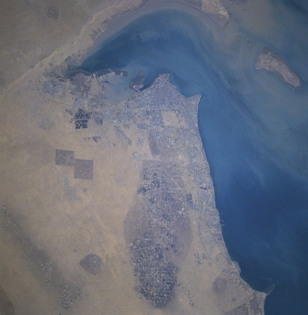 |
| STS080-733-021 Kuwait City, Al Burqan Oil Field, Kuwait November 1996 The Al Burqan Oil Field, the largest oil and gas field in the world, can be seen in this north-looking view. The oil-free desert sands are visible surrounding the large oil field complex. This was the site in early 1991 of over 530 oil well fires started by the invading Iraqi troops and engineers as part of their country's "scorched-earth policy." The oil well fires were distinguished in November of 1991. Five years later, pools or lakes of oil are visible throughout the oil field. Many of the wells have been put back into service. The country of Kuwait possesses about one-fifth of the world's oil reserves. To the north of the Al Burqan Oil Field, Kuwait City is discernible. New pivot-irrigation fields (dark circular features) developed since the end of the Gulf War are visible to the west (left) of the city. Oil refineries and large tanker facilities are discernible along the Persian Gulf coast. |
| Images: | All Available Images Low-Resolution 306k |
|
| Mission: | STS080 |
|
| Roll - Frame: | 733 - 21 |
|
| Geographical Name: | KUWAIT |
|
| Features: | KUWAIT CITY, OIL FIELD |
|
| Center Lat x Lon: | 29.5N x 48.0E |
|
| Film Exposure: | N | N=Normal exposure, U=Under exposed, O=Over exposed, F=out of Focus |
| Percentage of Cloud Cover-CLDP: | 0 |
|
| Camera:: | HB |
|
| Camera Tilt: | 28 | LO=Low Oblique, HO=High Oblique, NV=Near Vertical |
| Camera Focal Length: | 250 |
|
| Nadir to Photo Center Direction: | NE | The direction from the nadir to the center point, N=North, S=South, E=East, W=West |
| Stereo?: | Y | Y=Yes there is an adjacent picture of the same area, N=No there isn't |
| Orbit Number: | 165 |
|
| Date: | 19961130 | YYYYMMDD |
| Time: | 055005 | GMT HHMMSS |
| Nadir Lat: | 28.6N |
Latitude of suborbital point of spacecraft |
| Nadir Lon: | 46.6E |
Longitude of suborbital point of spacecraft |
| Sun Azimuth: | 136 | Clockwise angle in degrees from north to the sun measured at the nadir point |
| Space Craft Altitude: | 185 | nautical miles |
| Sun Elevation: | 25 | Angle in degrees between the horizon and the sun, measured at the nadir point |
| Land Views: | PLAIN, DESERT |
|
| Water Views: | GULF |
|
| Atmosphere Views: | |
|
| Man Made Views: | DRILLING, AGRICULTURE, PIVOT IRRIGATION, PORT, URBAN AREA |
|
| City Views: | KUWAIT CITY |
|
Photo is not associated with any sequences | ||
| NASA Home Page |
JSC Home Page |
JSC Digital Image Collection |
Earth Science & Remote Sensing |
|
This service is provided by the International Space Station program and the JSC Earth Science & Remote Sensing Unit, ARES Division, Exploration Integration Science Directorate.

|