Geographic Region: SINGAPORE
Feature: STREETS,DOCKS,SHIP WAKES
|
Geographic Region: SINGAPORE Feature: STREETS,DOCKS,SHIP WAKES |
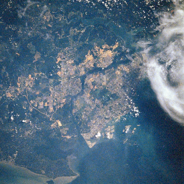 |
| STS080-711-005 Singapore November 1996 The city of Singapore (center of image), which now encompasses the whole island of Singapore, can be seen in this northeast-looking view. Singapore, which also means "Lion City," has a large natural harbor and is strategically located on the southern tip of the Malaysian Peninsula between the Strait of Malacca to the west (extreme bottom left of the image), and the South China Sea to the east (not visible on image). Singapore is one of the world's busiest port, a leading financial center, and a major supplier of electronics components. The city also has oil refineries and major shipbuilding and ship repair facilities. Singapore Island, once heavily forested, is low lying and is composed of a granitic core surrounded by sedimentary lowlands. The coast has many inlets and there are extensive mangrove swamps. The Malaysian city of Johor Baharu, a major trading center for rubber and tropical products, is visible just to the north of Singapore across the Johore Strait. |
| Images: | All Available Images Low-Resolution 457k |
|
| Mission: | STS080 |
|
| Roll - Frame: | 711 - 5 |
|
| Geographical Name: | SINGAPORE |
|
| Features: | STREETS,DOCKS,SHIP WAKES |
|
| Center Lat x Lon: | 1.5N x 103.5E |
|
| Film Exposure: | N | N=Normal exposure, U=Under exposed, O=Over exposed, F=out of Focus |
| Percentage of Cloud Cover-CLDP: | 5 |
|
| Camera:: | HB |
|
| Camera Tilt: | 7 | LO=Low Oblique, HO=High Oblique, NV=Near Vertical |
| Camera Focal Length: | 250 |
|
| Nadir to Photo Center Direction: | N | The direction from the nadir to the center point, N=North, S=South, E=East, W=West |
| Stereo?: | Y | Y=Yes there is an adjacent picture of the same area, N=No there isn't |
| Orbit Number: | 5 |
|
| Date: | 19961120 | YYYYMMDD |
| Time: | 014334 | GMT HHMMSS |
| Nadir Lat: | 1.1N |
Latitude of suborbital point of spacecraft |
| Nadir Lon: | 103.6E |
Longitude of suborbital point of spacecraft |
| Sun Azimuth: | 117 | Clockwise angle in degrees from north to the sun measured at the nadir point |
| Space Craft Altitude: | 190 | nautical miles |
| Sun Elevation: | 40 | Angle in degrees between the horizon and the sun, measured at the nadir point |
| Land Views: | ISLAND |
|
| Water Views: | STRAIT, SHIP WAKE |
|
| Atmosphere Views: | |
|
| Man Made Views: | URBAN AREA, HIGHWAY, BRIDGE, AGRICULTURE |
|
| City Views: | |
|
Photo is not associated with any sequences | ||
| NASA Home Page |
JSC Home Page |
JSC Digital Image Collection |
Earth Science & Remote Sensing |
|
This service is provided by the International Space Station program and the JSC Earth Science & Remote Sensing Unit, ARES Division, Exploration Integration Science Directorate.

|