Geographic Region: MEXICO
Feature: SIERRA SANTA CLARA,COAST
|
Geographic Region: MEXICO Feature: SIERRA SANTA CLARA,COAST |
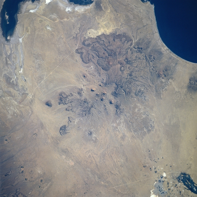 |
| STS080-706-008 Baja California, Mexico November 1996 Several large areas of volcanic activity, forming plateau-like features, are easily identified along the west coast of Baja California. The geologic structure in the center of the image is an old, severely eroded volcano, which is the southernmost feature of the Sierra Viscaino (also known as the Sierra Santa Clara). The center of the eroded caldera is visible almost exactly in the middle of the picture. More resistant large lava-formed lobes can be seen immediately south of the old caldera. The dark feature southeast of the volcano (upper left corner) is the northern end of Laguna San Ignacio, while the dark feature in the upper right corner of the image is Bahia San Hipolito. The light colored lines traversing this arid environment are roads that connect the coastal areas with the main highway that extends northwest to southeast throughout the Baja California peninsula. |
| Images: | All Available Images Low-Resolution 344k |
|
| Mission: | STS080 |
|
| Roll - Frame: | 706 - 8 |
|
| Geographical Name: | MEXICO |
|
| Features: | SIERRA SANTA CLARA,COAST |
|
| Center Lat x Lon: | 27.0N x 113.5W |
|
| Film Exposure: | N | N=Normal exposure, U=Under exposed, O=Over exposed, F=out of Focus |
| Percentage of Cloud Cover-CLDP: | 0 |
|
| Camera:: | HB |
|
| Camera Tilt: | 16 | LO=Low Oblique, HO=High Oblique, NV=Near Vertical |
| Camera Focal Length: | 250 |
|
| Nadir to Photo Center Direction: | NW | The direction from the nadir to the center point, N=North, S=South, E=East, W=West |
| Stereo?: | Y | Y=Yes there is an adjacent picture of the same area, N=No there isn't |
| Orbit Number: | 65 |
|
| Date: | 19961123 | YYYYMMDD |
| Time: | 213535 | GMT HHMMSS |
| Nadir Lat: | 26.3N |
Latitude of suborbital point of spacecraft |
| Nadir Lon: | 112.9W |
Longitude of suborbital point of spacecraft |
| Sun Azimuth: | 219 | Clockwise angle in degrees from north to the sun measured at the nadir point |
| Space Craft Altitude: | 191 | nautical miles |
| Sun Elevation: | 33 | Angle in degrees between the horizon and the sun, measured at the nadir point |
| Land Views: | VOLCANO |
|
| Water Views: | BAY |
|
| Atmosphere Views: | |
|
| Man Made Views: | HIGHWAY |
|
| City Views: | |
|
Photo is not associated with any sequences | ||
| NASA Home Page |
JSC Home Page |
JSC Digital Image Collection |
Earth Science & Remote Sensing |
|
This service is provided by the International Space Station program and the JSC Earth Science & Remote Sensing Unit, ARES Division, Exploration Integration Science Directorate.

|