
Geographic Region: MEXICO
Feature: SAN LUIS POTOSI, AGR.
|
Geographic Region: MEXICO Feature: SAN LUIS POTOSI, AGR. |
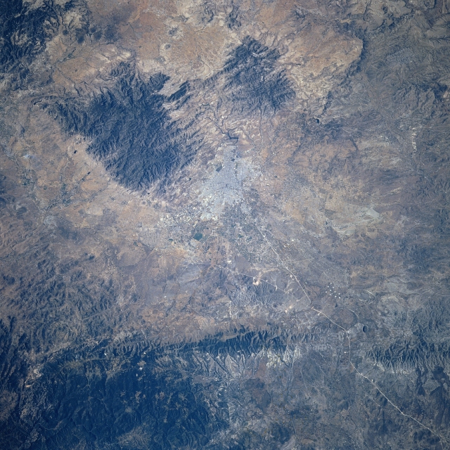 |
| STS080-702-095 San Luis Potosi, Mexico November 1996 The concentration of highly reflective surfaces (near the center of the image) is the city of San Luis Potosi. In addition to being located on the arid to semi-arid Mexican Plateau that averages 6500 feet - 1980 meters above sea level, San Luis Potosi is flanked by several mountain ranges (darker, eroded features), particularly west, south, and even east of the developing urban area. San Luis Potosi is favorably located to function as an important ground transportation hub for central Mexico (the thin, light colored lines appear to be recently constructed highways). For example consider that the so-called NAFTA (North American Free Trade Agreement) Highway, basically a north-south artery, passes through the city. There is also an east-west highway linkage that connects the Gulf of Mexico coast with the west coast of Mexico that also passes through the city. San Luis Potosi is an important stop for one of Mexico's principal railroad lines (railroad right of way is very difficult to trace across the computer image). |
| Images: | All Available Images Low-Resolution 391k |
|
| Mission: | STS080 |
|
| Roll - Frame: | 702 - 95 |
|
| Geographical Name: | MEXICO |
|
| Features: | SAN LUIS POTOSI, AGR. |
|
| Center Lat x Lon: | 22.0N x 101W |
|
| Film Exposure: | F | N=Normal exposure, U=Under exposed, O=Over exposed, F=out of Focus |
| Percentage of Cloud Cover-CLDP: | 0 |
|
| Camera:: | HB |
|
| Camera Tilt: | 18 | LO=Low Oblique, HO=High Oblique, NV=Near Vertical |
| Camera Focal Length: | 250 |
|
| Nadir to Photo Center Direction: | SW | The direction from the nadir to the center point, N=North, S=South, E=East, W=West |
| Stereo?: | N | Y=Yes there is an adjacent picture of the same area, N=No there isn't |
| Orbit Number: | 31 |
|
| Date: | 19961121 | YYYYMMDD |
| Time: | 173252 | GMT HHMMSS |
| Nadir Lat: | 22.5N |
Latitude of suborbital point of spacecraft |
| Nadir Lon: | 100.1W |
Longitude of suborbital point of spacecraft |
| Sun Azimuth: | 162 | Clockwise angle in degrees from north to the sun measured at the nadir point |
| Space Craft Altitude: | 189 | nautical miles |
| Sun Elevation: | 46 | Angle in degrees between the horizon and the sun, measured at the nadir point |
| Land Views: | PLATEAU, MOUNTAIN |
|
| Water Views: | |
|
| Atmosphere Views: | |
|
| Man Made Views: | HIGHWAY |
|
| City Views: | |
|
Photo is not associated with any sequences | ||
| NASA Home Page |
JSC Home Page |
JSC Digital Image Collection |
Earth Science & Remote Sensing |
|
This service is provided by the International Space Station program and the JSC Earth Science & Remote Sensing Unit, ARES Division, Exploration Integration Science Directorate.

|