
Geographic Region: MEXICO
Feature: AGUASCALIENTES,AGR.,RES.
|
Geographic Region: MEXICO Feature: AGUASCALIENTES,AGR.,RES. |
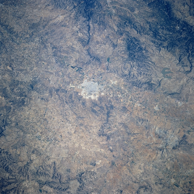 |
| STS080-702-094 Aguascalientes Area, Mexico November 1996 Aguascalientes, the highly reflective area near the center of the image, is the capital of the state with the same name. Located approximately 110 miles (175 km) northeast of Guadalajara, this urban area located on the Mexican Plateau (6486 feet - 1977 meters above sea level) was named for the numerous thermal springs that are found in the area. This region of the semi-arid Mexican Plateau is characterized by rugged mountains (darker features west of the city) separated by basins. Some of the elevated landscape (slightly darker features) display evidence of recent volcanic activity. The meandering channel of the Rio Verde Grande de Balem (aligned north-south) can be seen as it passes along the west side of Aguascalientes. The Presidente Calles Reservoir is barely visible (shaped like letter E) north, northwest of the city. |
| Images: | All Available Images Low-Resolution 411k |
|
| Mission: | STS080 |
|
| Roll - Frame: | 702 - 94 |
|
| Geographical Name: | MEXICO |
|
| Features: | AGUASCALIENTES,AGR.,RES. |
|
| Center Lat x Lon: | 22.0N x 102.5W |
|
| Film Exposure: | N | N=Normal exposure, U=Under exposed, O=Over exposed, F=out of Focus |
| Percentage of Cloud Cover-CLDP: | 0 |
|
| Camera:: | HB |
|
| Camera Tilt: | 29 | LO=Low Oblique, HO=High Oblique, NV=Near Vertical |
| Camera Focal Length: | 250 |
|
| Nadir to Photo Center Direction: | W | The direction from the nadir to the center point, N=North, S=South, E=East, W=West |
| Stereo?: | N | Y=Yes there is an adjacent picture of the same area, N=No there isn't |
| Orbit Number: | 31 |
|
| Date: | 19961121 | YYYYMMDD |
| Time: | 173241 | GMT HHMMSS |
| Nadir Lat: | 22.2N |
Latitude of suborbital point of spacecraft |
| Nadir Lon: | 100.8W |
Longitude of suborbital point of spacecraft |
| Sun Azimuth: | 161 | Clockwise angle in degrees from north to the sun measured at the nadir point |
| Space Craft Altitude: | 189 | nautical miles |
| Sun Elevation: | 46 | Angle in degrees between the horizon and the sun, measured at the nadir point |
| Land Views: | MOUNTAIN, PLATEAU |
|
| Water Views: | RIVER, RESERVOIR |
|
| Atmosphere Views: | |
|
| Man Made Views: | |
|
| City Views: | |
|
Photo is not associated with any sequences | ||
| NASA Home Page |
JSC Home Page |
JSC Digital Image Collection |
Earth Science & Remote Sensing |
|
This service is provided by the International Space Station program and the JSC Earth Science & Remote Sensing Unit, ARES Division, Exploration Integration Science Directorate.

|