Geographic Region: NEW ZEALAND-SI
Feature: CANTERBURY PLAINS, SOUTHERN ALPS
|
Geographic Region: NEW ZEALAND-SI Feature: CANTERBURY PLAINS, SOUTHERN ALPS |
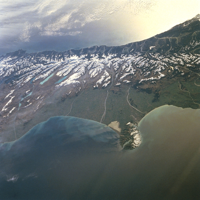 |
| STS079-835-68 Canterbury Plain, Southern Alps, New Zealand September 1996 In this west-looking view, the snow-covered Southern Alps of central South Island, New Zealand can be seen. Running southwest to northeast along the western coast of South Island, the Southern Alps are rugged mountains made up of numerous peaks in excess of 9842 feet (3000 meters). Within the Southern Alps, there are over 3100 active glaciers. Evergreen woodlands dot the western coast and many glacial lakes are visible on the eastern slopes of the mountains. Just below the center of the image, the Canterbury Plain, the largest area of fertile, flat land in New Zealand, is visible. Braided rivers up to 16 miles (25 km) wide are discernible crossing the plain. The Banks Peninsula, formed following a violent eruption of two volcanoes, extends outward from the east coast into the Pacific Ocean. The peninsula is 35 miles (56 km) long and 25 miles (40 km) wide. The bright area off the west coast of the island is caused by sun glint off the waters of the Tasman Sea. New Zealand is on the tectonic plate boundary between the Pacific and the Indian-Australian plates. In the center of the view, the near-vertical Alpine fault zone sharply defines the plate edge. The coastal zone west of the fault is moving north (to the right) relative to the alpine country on the opposite side. Farther north (right edge of frame) the fault zone begins to step northeastward from South Island to North Island; this view clearly illustrates the change in fault pattern at the jog in the plate boundary. |
| Images: | All Available Images Low-Resolution 348k |
|
| Mission: | STS079 |
|
| Roll - Frame: | 835 - 68 |
|
| Geographical Name: | NEW ZEALAND-SI |
|
| Features: | CANTERBURY PLAINS, SOUTHERN ALPS |
|
| Center Lat x Lon: | 44.5S x 170.5E |
|
| Film Exposure: | N | N=Normal exposure, U=Under exposed, O=Over exposed, F=out of Focus |
| Percentage of Cloud Cover-CLDP: | 5 |
|
| Camera:: | HB |
|
| Camera Tilt: | HO | LO=Low Oblique, HO=High Oblique, NV=Near Vertical |
| Camera Focal Length: | 100 |
|
| Nadir to Photo Center Direction: | W | The direction from the nadir to the center point, N=North, S=South, E=East, W=West |
| Stereo?: | N | Y=Yes there is an adjacent picture of the same area, N=No there isn't |
| Orbit Number: | 76 |
|
| Date: | 19960921 | YYYYMMDD |
| Time: | 033401 | GMT HHMMSS |
| Nadir Lat: | 44.4S |
Latitude of suborbital point of spacecraft |
| Nadir Lon: | 177.0E |
Longitude of suborbital point of spacecraft |
| Sun Azimuth: | 299 | Clockwise angle in degrees from north to the sun measured at the nadir point |
| Space Craft Altitude: | 207 | nautical miles |
| Sun Elevation: | 26 | Angle in degrees between the horizon and the sun, measured at the nadir point |
| Land Views: | MOUNTAIN, GLACIER, PLAIN, COAST |
|
| Water Views: | LAKE, RIVER |
|
| Atmosphere Views: | |
|
| Man Made Views: | |
|
| City Views: | |
|
Photo is not associated with any sequences | ||
| NASA Home Page |
JSC Home Page |
JSC Digital Image Collection |
Earth Science & Remote Sensing |
|
This service is provided by the International Space Station program and the JSC Earth Science & Remote Sensing Unit, ARES Division, Exploration Integration Science Directorate.

|