
Geographic Region: AUSTRALIA-NSW
Feature: SYDNEY
|
Geographic Region: AUSTRALIA-NSW Feature: SYDNEY |
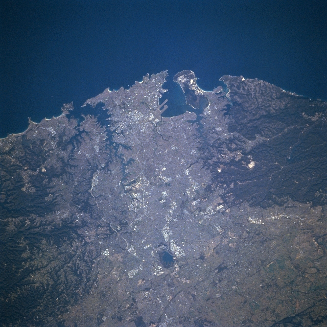 |
| STS079-834-006 Sydney, New South Wales, Australia September 1996 The areal extent of Australia's largest city, Sydney that is located along the southeast coast of the continent with a population of almost 4 million people, can be discerned by the lighter-colored landscape. The darker terrain south of the sprawling urban area shows Heathcote and Royal National Parks, while the darker area north (lower left) of Sydney is Kur-ing-gai Chase National Park. Sydney is noted as a city of green areas, famous waterfront and harbor area, great beaches, and friendly citizens. The extensive, serpentine-shaped water feature (upper left quadrant) is Sydney Harbor. The other large bay (top center) is Botany Bay where the twin runways (linear, light-colored features) of Sydney International Airport jut southward into Botany Bay. The other dark-colored water feature is Prospect Reservoir (slightly below center). |
| Images: | All Available Images Low-Resolution 362k |
|
| Mission: | STS079 |
|
| Roll - Frame: | 834 - 6 |
|
| Geographical Name: | AUSTRALIA-NSW |
|
| Features: | SYDNEY |
|
| Center Lat x Lon: | 34S x 150.5E |
|
| Film Exposure: | N | N=Normal exposure, U=Under exposed, O=Over exposed, F=out of Focus |
| Percentage of Cloud Cover-CLDP: | 0 |
|
| Camera:: | HB |
|
| Camera Tilt: | 26 | LO=Low Oblique, HO=High Oblique, NV=Near Vertical |
| Camera Focal Length: | 250 |
|
| Nadir to Photo Center Direction: | W | The direction from the nadir to the center point, N=North, S=South, E=East, W=West |
| Stereo?: | Y | Y=Yes there is an adjacent picture of the same area, N=No there isn't |
| Orbit Number: | 30 |
|
| Date: | 19960918 | YYYYMMDD |
| Time: | 051122 | GMT HHMMSS |
| Nadir Lat: | 33.6S |
Latitude of suborbital point of spacecraft |
| Nadir Lon: | 151.7E |
Longitude of suborbital point of spacecraft |
| Sun Azimuth: | 296 | Clockwise angle in degrees from north to the sun measured at the nadir point |
| Space Craft Altitude: | 156 | nautical miles |
| Sun Elevation: | 30 | Angle in degrees between the horizon and the sun, measured at the nadir point |
| Land Views: | FOREST, RANGE |
|
| Water Views: | BAY |
|
| Atmosphere Views: | |
|
| Man Made Views: | URBAN AREA |
|
| City Views: | SYDNEY |
|
Photo is not associated with any sequences | ||
| NASA Home Page |
JSC Home Page |
JSC Digital Image Collection |
Earth Science & Remote Sensing |
|
This service is provided by the International Space Station program and the JSC Earth Science & Remote Sensing Unit, ARES Division, Exploration Integration Science Directorate.

|