
Geographic Region: USA-TENNESSEE
Feature: MEMPHIS, MISSISSIPPI R.
|
Geographic Region: USA-TENNESSEE Feature: MEMPHIS, MISSISSIPPI R. |
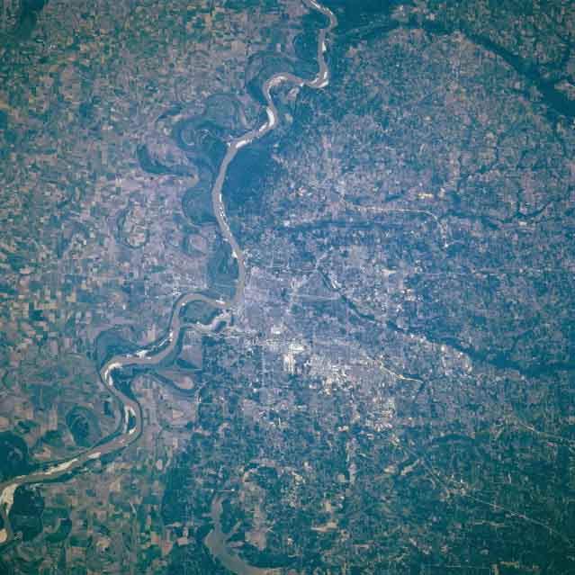 |
| STS079-812-086 Mississippi River, Memphis Tennessee September 1996 Memphis Tennessee is located on the Chickasaw Bluffs overlooking the east bank of the Mississippi River at the confluence of the Wolf River. Memphis is the largest city in the state of Tennessee and is situated in a rich cotton and lumber-producing region. It is one of the busiest inland ports on the Mississippi River. Memphis is one of the world's largest markets for spot cotton and hardwood lumber. The city is a leading commercial, industrial, and distribution center. Memphis also has extensive medical and education facilities. Numerous sandbars are visible along the river course. The vast floodplain of the Mississippi River, with its numerous agricultural fields, is visible to the west (left) of the river in Arkansas. Near the bottom center of the image, the sediment-laded waters of Lake Arkabutla in northwestern Mississippi can be seen. |
| Images: | All Available Images Low-Resolution 49k |
|
| Mission: | STS079 |
|
| Roll - Frame: | 812 - 86 |
|
| Geographical Name: | USA-TENNESSEE |
|
| Features: | MEMPHIS, MISSISSIPPI R. |
|
| Center Lat x Lon: | 35.0N x 90W |
|
| Film Exposure: | N | N=Normal exposure, U=Under exposed, O=Over exposed, F=out of Focus |
| Percentage of Cloud Cover-CLDP: | 0 |
|
| Camera:: | HB |
|
| Camera Tilt: | 28 | LO=Low Oblique, HO=High Oblique, NV=Near Vertical |
| Camera Focal Length: | 250 |
|
| Nadir to Photo Center Direction: | NE | The direction from the nadir to the center point, N=North, S=South, E=East, W=West |
| Stereo?: | N | Y=Yes there is an adjacent picture of the same area, N=No there isn't |
| Orbit Number: | 115 |
|
| Date: | 19960923 | YYYYMMDD |
| Time: | 145940 | GMT HHMMSS |
| Nadir Lat: | 33.5N |
Latitude of suborbital point of spacecraft |
| Nadir Lon: | 90.9W |
Longitude of suborbital point of spacecraft |
| Sun Azimuth: | 120 | Clockwise angle in degrees from north to the sun measured at the nadir point |
| Space Craft Altitude: | 201 | nautical miles |
| Sun Elevation: | 37 | Angle in degrees between the horizon and the sun, measured at the nadir point |
| Land Views: | PLAIN |
|
| Water Views: | RIVER, LAKE |
|
| Atmosphere Views: | |
|
| Man Made Views: | URBAN AREA, AGRICULTURE |
|
| City Views: | |
|
Photo is not associated with any sequences | ||
| NASA Home Page |
JSC Home Page |
JSC Digital Image Collection |
Earth Science & Remote Sensing |
|
This service is provided by the International Space Station program and the JSC Earth Science & Remote Sensing Unit, ARES Division, Exploration Integration Science Directorate.

|