
Geographic Region: USA-MISSISSIPPI
Feature: MISSISSIPPI R,CLARKSDALE
|
Geographic Region: USA-MISSISSIPPI Feature: MISSISSIPPI R,CLARKSDALE |
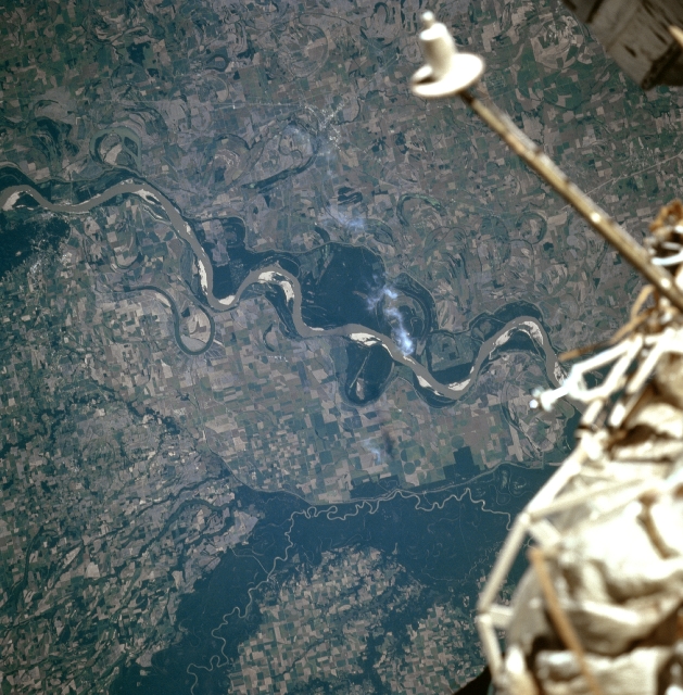 |
| STS079-812-085 Mississippi and White Rivers, Arkansas September 1996 The Mississippi River is the largest river system in the United States draining nearly one-third of the country. Only the Nile River of Africa and the Amazon River of South America drain larger areas. Rich agricultural lands, created by thousands of years of river flooding and meandering, are visible on both sides of the river. Midway between the center and right center of the image, the small city of Clarksdale, Mississippi is discernible. Clarksdale is a processing and distribution center in a rich cotton producing area. To the west (left) of the Mississippi River, the meandering White River in Arkansas is visible. The river is forested on both sides and these forested lands have been set-aside as a National Wildlife Refuge area. The area outside the refuge is agricultural and is easily distinguished from the refuge. The White River, 690 miles (1110 km) long, rises in the Boston Mountains of northwestern Arkansas, and is navigable for shallow-draft vessels 300 miles (480 km) upstream from where the river enters the Mississippi River. |
| Images: | All Available Images Low-Resolution 359k |
|
| Mission: | STS079 |
|
| Roll - Frame: | 812 - 85 |
|
| Geographical Name: | USA-MISSISSIPPI |
|
| Features: | MISSISSIPPI R,CLARKSDALE |
|
| Center Lat x Lon: | 34.0N x 91W |
|
| Film Exposure: | N | N=Normal exposure, U=Under exposed, O=Over exposed, F=out of Focus |
| Percentage of Cloud Cover-CLDP: | 0 |
|
| Camera:: | HB |
|
| Camera Tilt: | 8 | LO=Low Oblique, HO=High Oblique, NV=Near Vertical |
| Camera Focal Length: | 250 |
|
| Nadir to Photo Center Direction: | NE | The direction from the nadir to the center point, N=North, S=South, E=East, W=West |
| Stereo?: | N | Y=Yes there is an adjacent picture of the same area, N=No there isn't |
| Orbit Number: | 115 |
|
| Date: | 19960923 | YYYYMMDD |
| Time: | 145932 | GMT HHMMSS |
| Nadir Lat: | 33.8N |
Latitude of suborbital point of spacecraft |
| Nadir Lon: | 91.4W |
Longitude of suborbital point of spacecraft |
| Sun Azimuth: | 120 | Clockwise angle in degrees from north to the sun measured at the nadir point |
| Space Craft Altitude: | 201 | nautical miles |
| Sun Elevation: | 36 | Angle in degrees between the horizon and the sun, measured at the nadir point |
| Land Views: | FLOOD PLAIN, VALLEY, FOREST |
|
| Water Views: | RIVER, LAKE |
|
| Atmosphere Views: | |
|
| Man Made Views: | AGRICULTURE |
|
| City Views: | |
|
Photo is not associated with any sequences | ||
| NASA Home Page |
JSC Home Page |
JSC Digital Image Collection |
Earth Science & Remote Sensing |
|
This service is provided by the International Space Station program and the JSC Earth Science & Remote Sensing Unit, ARES Division, Exploration Integration Science Directorate.

|