
Geographic Region: ISRAEL
Feature: HAIFA, LAKE TIBERIAS
|
Geographic Region: ISRAEL Feature: HAIFA, LAKE TIBERIAS |
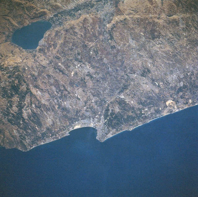 |
| STS079-810-049 Haifa, Lake Tiberias, Israel September 1996 The third largest city in Israel, the coastal city of Haifa, situated midway between the center and bottom center of the image, is visible in this southeast-looking view. Haifa is the main port of Israel and is the country's industrial center as well. Major industries include oil refineries, food processing, shipbuilding, chemicals, electrical equipment, steel, and textiles. In the upper left corner of the image, the pear-shaped freshwater Lake Tiberias (Sea of Galilee) can be seen. Lake Tiberias is 14 miles (23 km) long and has a maximum width of 8 miles (13 km). The lake has a maximum depth of 150 feet (46 meters) and covers an area of 64 square miles (165 square km). Lake Tiberias lies 680 feet (207 meters) below sea level and its bed forms part of the Dead Sea Rift Valley. At one time in the geologic past, Lake Tiberias was part of a great inland sea that extended from the Hula marshes in Northern Israel to a point 40 miles (64 km) south of the Dead Sea. The lake is completely encircled by beach, and bordered by escarpments and plains. Tourism and fishing are the main industries around the lake. |
| Images: | All Available Images Low-Resolution 396k |
|
| Mission: | STS079 |
|
| Roll - Frame: | 810 - 49 |
|
| Geographical Name: | ISRAEL |
|
| Features: | HAIFA, LAKE TIBERIAS |
|
| Center Lat x Lon: | 33.0N x 35.0E |
|
| Film Exposure: | N | N=Normal exposure, U=Under exposed, O=Over exposed, F=out of Focus |
| Percentage of Cloud Cover-CLDP: | 0 |
|
| Camera:: | HB |
|
| Camera Tilt: | 19 | LO=Low Oblique, HO=High Oblique, NV=Near Vertical |
| Camera Focal Length: | 250 |
|
| Nadir to Photo Center Direction: | SE | The direction from the nadir to the center point, N=North, S=South, E=East, W=West |
| Stereo?: | Y | Y=Yes there is an adjacent picture of the same area, N=No there isn't |
| Orbit Number: | 125 |
|
| Date: | 19960924 | YYYYMMDD |
| Time: | 062034 | GMT HHMMSS |
| Nadir Lat: | 33.9N |
Latitude of suborbital point of spacecraft |
| Nadir Lon: | 34.3E |
Longitude of suborbital point of spacecraft |
| Sun Azimuth: | 117 | Clockwise angle in degrees from north to the sun measured at the nadir point |
| Space Craft Altitude: | 201 | nautical miles |
| Sun Elevation: | 33 | Angle in degrees between the horizon and the sun, measured at the nadir point |
| Land Views: | COAST, HILL, RIFT, ESCARPMENT |
|
| Water Views: | LAKE, SEA |
|
| Atmosphere Views: | |
|
| Man Made Views: | URBAN AREA |
|
| City Views: | |
|
Photo is not associated with any sequences | ||
| NASA Home Page |
JSC Home Page |
JSC Digital Image Collection |
Earth Science & Remote Sensing |
|
This service is provided by the International Space Station program and the JSC Earth Science & Remote Sensing Unit, ARES Division, Exploration Integration Science Directorate.

|