
Geographic Region: USA-CALIFORNIA
Feature: LAKE TAHOE,SIERRA NEVADA
|
Geographic Region: USA-CALIFORNIA Feature: LAKE TAHOE,SIERRA NEVADA |
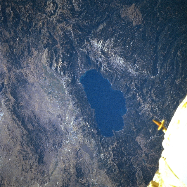 |
| STS079-810-003 Lake Tahoe, California, USA September 1996 Located on the California-Nevada border (two thirds in California and one third in Nevada), Lake Tahoe (large dark blue feature in the center of image) measures about 22 miles (35 kilometers) long and 12 miles (19 kilometers) wide. Lake Tahoe's average surface elevation is 6225 (1897 meters) above sea level and its maximum depth measures 1645 feet (501 meters), making the lake the third deepest lake in North America. The actual surface elevation of the lake is controlled by how much water flows into the lake from the surrounding mountains and how much water flows out of the lake and into the Truckee River controlled by the dam at Tahoe City. The Lake Tahoe Basin was created over millions of years by two major faulting events: the elevation of the Carson Range of mountains along the eastern margin of the basin and the development of the Sierra Nevada mountains along the western side of the basin. The gray waters of shallow Washoe Lake are in the bottom center of the photograph. Carson City, the capital of Nevada, can be seen as light gray areas in the desert valley to the east (left) of the Lake Tahoe, just south (above) Washoe Lake. The white object in the lower right corner of the picture is part of the Space Shuttle. |
| Images: | All Available Images Low-Resolution 396k |
|
| Mission: | STS079 |
|
| Roll - Frame: | 810 - 3 |
|
| Geographical Name: | USA-CALIFORNIA |
|
| Features: | LAKE TAHOE,SIERRA NEVADA |
|
| Center Lat x Lon: | 39.0N x 120W |
|
| Film Exposure: | N | N=Normal exposure, U=Under exposed, O=Over exposed, F=out of Focus |
| Percentage of Cloud Cover-CLDP: | 0 |
|
| Camera:: | HB |
|
| Camera Tilt: | 32 | LO=Low Oblique, HO=High Oblique, NV=Near Vertical |
| Camera Focal Length: | 250 |
|
| Nadir to Photo Center Direction: | E | The direction from the nadir to the center point, N=North, S=South, E=East, W=West |
| Stereo?: | Y | Y=Yes there is an adjacent picture of the same area, N=No there isn't |
| Orbit Number: | 116 |
|
| Date: | 19960923 | YYYYMMDD |
| Time: | 162926 | GMT HHMMSS |
| Nadir Lat: | 39.0N |
Latitude of suborbital point of spacecraft |
| Nadir Lon: | 122.1W |
Longitude of suborbital point of spacecraft |
| Sun Azimuth: | 116 | Clockwise angle in degrees from north to the sun measured at the nadir point |
| Space Craft Altitude: | 201 | nautical miles |
| Sun Elevation: | 28 | Angle in degrees between the horizon and the sun, measured at the nadir point |
| Land Views: | MOUNTAIN |
|
| Water Views: | LAKE |
|
| Atmosphere Views: | |
|
| Man Made Views: | |
|
| City Views: | |
|
Photo is not associated with any sequences | ||
| NASA Home Page |
JSC Home Page |
JSC Digital Image Collection |
Earth Science & Remote Sensing |
|
This service is provided by the International Space Station program and the JSC Earth Science & Remote Sensing Unit, ARES Division, Exploration Integration Science Directorate.

|