
Geographic Region: USA-CALIFORNIA
Feature: AGRICULTURE, LAKE, CHICO
|
Geographic Region: USA-CALIFORNIA Feature: AGRICULTURE, LAKE, CHICO |
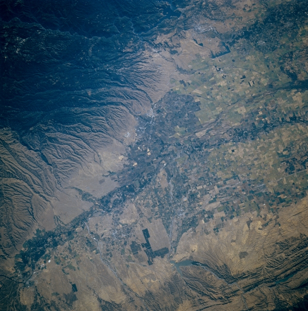 |
| STS079-810-001 Sacramento Valley, California, USA September 1996 The Sacramento River Valley is a flat, fertile plain that is flanked by high mountains to the east and lower but rugged hills to the west. The central valley of the Sacramento Basin narrows near the northern end of the valley. The deeply eroded and wooded southwestern flank of a mountain range that includes Mt. Lassen (not in this image) covers the northeastern third of the picture (dark terrain). Several lower, paralleling hilly ridges are visible along the western side of the valley. Black Butte Lake, a small Y-shaped reservoir, is barely visible near the edge of these folded beds (west center). Within the valley, the Sacramento River floodplain (and the river's channels) can be traced across a landscape that is covered by a multitude of cultivated fields (angular-looking patterns, variety of colors). Interstate Highway 5 is observed as it runs north-south along the western side of the Sacramento Valley. The location of Chico (gray fine-textured feature) is barely discernible along the eastern side of the valley. |
| Images: | All Available Images Low-Resolution 377k |
|
| Mission: | STS079 |
|
| Roll - Frame: | 810 - 1 |
|
| Geographical Name: | USA-CALIFORNIA |
|
| Features: | AGRICULTURE, LAKE, CHICO |
|
| Center Lat x Lon: | 39.5N x 122W |
|
| Film Exposure: | N | N=Normal exposure, U=Under exposed, O=Over exposed, F=out of Focus |
| Percentage of Cloud Cover-CLDP: | 0 |
|
| Camera:: | HB |
|
| Camera Tilt: | 30 | LO=Low Oblique, HO=High Oblique, NV=Near Vertical |
| Camera Focal Length: | 250 |
|
| Nadir to Photo Center Direction: | E | The direction from the nadir to the center point, N=North, S=South, E=East, W=West |
| Stereo?: | N | Y=Yes there is an adjacent picture of the same area, N=No there isn't |
| Orbit Number: | 116 |
|
| Date: | 19960923 | YYYYMMDD |
| Time: | 162859 | GMT HHMMSS |
| Nadir Lat: | 40.1N |
Latitude of suborbital point of spacecraft |
| Nadir Lon: | 123.8W |
Longitude of suborbital point of spacecraft |
| Sun Azimuth: | 115 | Clockwise angle in degrees from north to the sun measured at the nadir point |
| Space Craft Altitude: | 201 | nautical miles |
| Sun Elevation: | 26 | Angle in degrees between the horizon and the sun, measured at the nadir point |
| Land Views: | VALLEY, MOUNTAIN |
|
| Water Views: | RIVER, LAKE |
|
| Atmosphere Views: | |
|
| Man Made Views: | AGRICULTURE |
|
| City Views: | |
|
Photo is not associated with any sequences | ||
| NASA Home Page |
JSC Home Page |
JSC Digital Image Collection |
Earth Science & Remote Sensing |
|
This service is provided by the International Space Station program and the JSC Earth Science & Remote Sensing Unit, ARES Division, Exploration Integration Science Directorate.

|