 Photo #: STS079-785-16 Date: Sep. 1996
Geographic Region: BOLIVIA
Feature: PAN-SALAR DE UYUNI,COAST

 Photo #: STS079-785-16 Date: Sep. 1996 Photo #: STS079-785-16 Date: Sep. 1996Geographic Region: BOLIVIA Feature: PAN-SALAR DE UYUNI,COAST |
 |
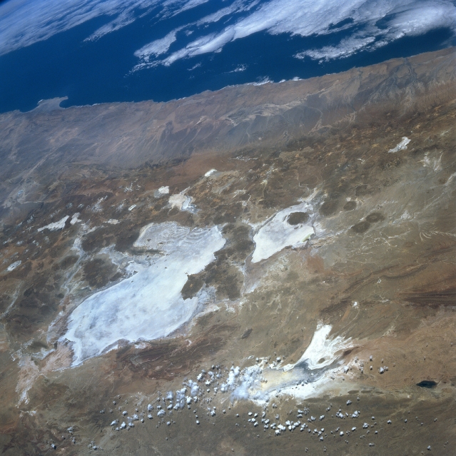
| STS079-785-016 Lake Poopo, Salar de Uyuni, Bolivia September 1996 Numerous bright salars or salt flats are visible in this westerly view of the southwestern part of the Altiplano in Bolivia. Many volcanic cones (darker, roughly circular features) are visible, mainly along the western flanks of the two large salars, Uyuni (largest) and Coipasa. Lake Poopo, a light colored feature northeast of the two large salars, appears to be relatively devoid of standing water at the time this image was obtained. Some clouds partially obscure the southern end of intermittently water filled Lake Poopo. The Andes Mountains dramatically decrease in elevation in a relatively short horizontal distance along the western slopes of the mountains. Known as the Atacama Desert of northern Chile, this synoptic view shows a large section of one of the most arid regions on earth. |
| Images: | All Available Images Low-Resolution 336k |
|
| Mission: | STS079 |
|
| Roll - Frame: | 785 - 16 |
|
| Geographical Name: | BOLIVIA |
|
| Features: | PAN-SALAR DE UYUNI,COAST |
|
| Center Lat x Lon: | 20S x 68W |
|
| Film Exposure: | N | N=Normal exposure, U=Under exposed, O=Over exposed, F=out of Focus |
| Percentage of Cloud Cover-CLDP: | 5 |
|
| Camera:: | HB |
|
| Camera Tilt: | HO | LO=Low Oblique, HO=High Oblique, NV=Near Vertical |
| Camera Focal Length: | 100 |
|
| Nadir to Photo Center Direction: | SW | The direction from the nadir to the center point, N=North, S=South, E=East, W=West |
| Stereo?: | N | Y=Yes there is an adjacent picture of the same area, N=No there isn't |
| Orbit Number: | 131 |
|
| Date: | 19960924 | YYYYMMDD |
| Time: | 155015 | GMT HHMMSS |
| Nadir Lat: | 16.8S |
Latitude of suborbital point of spacecraft |
| Nadir Lon: | 64.8W |
Longitude of suborbital point of spacecraft |
| Sun Azimuth: | 18 | Clockwise angle in degrees from north to the sun measured at the nadir point |
| Space Craft Altitude: | 203 | nautical miles |
| Sun Elevation: | 73 | Angle in degrees between the horizon and the sun, measured at the nadir point |
| Land Views: | SALAR, VOLCANO, DESERT |
|
| Water Views: | LAKE |
|
| Atmosphere Views: | |
|
| Man Made Views: | |
|
| City Views: | |
|
Photo is not associated with any sequences | ||
| NASA Home Page |
JSC Home Page |
JSC Digital Image Collection |
Earth Science & Remote Sensing |
|
|