
Geographic Region: CYPRUS
Feature: ENTIRE ISLAND,CLOUD EDDY
|
Geographic Region: CYPRUS Feature: ENTIRE ISLAND,CLOUD EDDY |
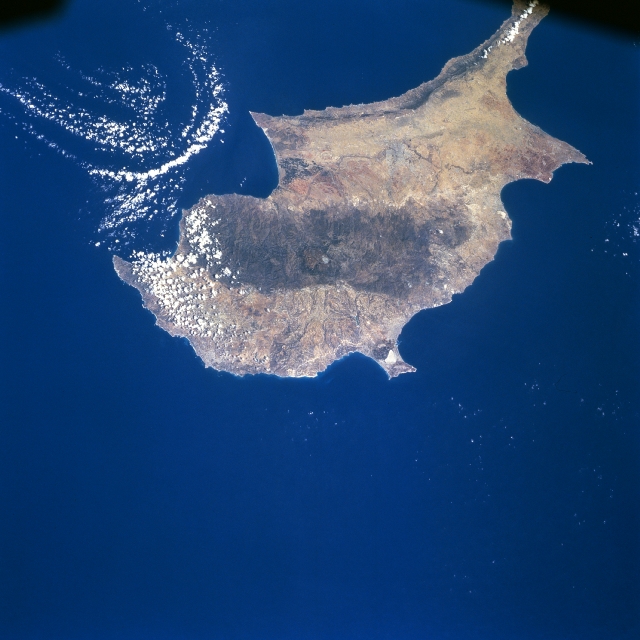 |
| STS079-782-050 The Island of Cyprus September 1996 Covering an area of 3578 sq. miles (9267 sq. km) and located in the eastern Mediterranean Sea, the island of Cyprus can be seen in this northeast-looking view. Cyprus is located 40 miles (60 km) south of Turkey and 60 miles (100 km) west of Syria. There are three main geographic regions on Cyprus. The Troodos Massif, consisting of mostly volcanic rock and some limestone, traverses the southwest portion of the island (darker feature near the center of the image). Iron and copper pyrites are found in the foothills and asbestos and chromium in the higher slopes of the Troodos. The highest elevation in the massif is 6406 feet (1953 meters). Numerous government-owned forests cover the Troodos Massif. On the north coast is the Kyrenia Range, a narrow mountain range reaching elevations of 3000 feet (1000 meters). Consisting mainly of limestone, the range is wooded. Between the two mountain ranges is the Central Plain, where seventy percent of the island's agriculture is located. The capital city of Cyprus, Nicosia, is situated on the Central Plain. The plain consists of a limestone crust and is considered a flat tableland. Heavily forested in ancient times, today the plain is almost treeless. |
| Images: | All Available Images Low-Resolution 277k |
|
| Mission: | STS079 |
|
| Roll - Frame: | 782 - 50 |
|
| Geographical Name: | CYPRUS |
|
| Features: | ENTIRE ISLAND,CLOUD EDDY |
|
| Center Lat x Lon: | 35.0N x 33.0E |
|
| Film Exposure: | N | N=Normal exposure, U=Under exposed, O=Over exposed, F=out of Focus |
| Percentage of Cloud Cover-CLDP: | 5 |
|
| Camera:: | HB |
|
| Camera Tilt: | 37 | LO=Low Oblique, HO=High Oblique, NV=Near Vertical |
| Camera Focal Length: | 100 |
|
| Nadir to Photo Center Direction: | NE | The direction from the nadir to the center point, N=North, S=South, E=East, W=West |
| Stereo?: | N | Y=Yes there is an adjacent picture of the same area, N=No there isn't |
| Orbit Number: | 17 |
|
| Date: | 19960917 | YYYYMMDD |
| Time: | 092000 | GMT HHMMSS |
| Nadir Lat: | 34.0N |
Latitude of suborbital point of spacecraft |
| Nadir Lon: | 31.3E |
Longitude of suborbital point of spacecraft |
| Sun Azimuth: | 166 | Clockwise angle in degrees from north to the sun measured at the nadir point |
| Space Craft Altitude: | 157 | nautical miles |
| Sun Elevation: | 58 | Angle in degrees between the horizon and the sun, measured at the nadir point |
| Land Views: | ISLAND, MOUNTAIN, FOREST, PLAIN, COAST |
|
| Water Views: | SEA |
|
| Atmosphere Views: | |
|
| Man Made Views: | |
|
| City Views: | |
|
Photo is not associated with any sequences | ||
| NASA Home Page |
JSC Home Page |
JSC Digital Image Collection |
Earth Science & Remote Sensing |
|
This service is provided by the International Space Station program and the JSC Earth Science & Remote Sensing Unit, ARES Division, Exploration Integration Science Directorate.

|