
Geographic Region: BOSNIA-HERZEGOVINA
Feature: DINARIC ALPS
|
Geographic Region: BOSNIA-HERZEGOVINA Feature: DINARIC ALPS |
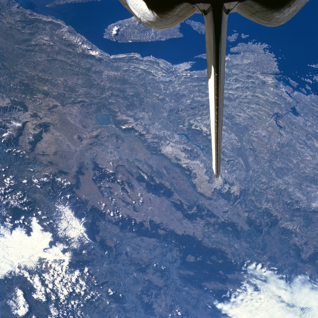 |
| STS079-782-046 Dinaric Alps, Croatia; Bosnia-Herzecovina September 1996 A section of the rugged Dinaric Alps are visible in this south-looking view. The Dinaric Alps that extend 400 miles (645 km) along the coast of the Adriatic Sea, are composed of limestone and dolomite and are a barrier to travel from the coast to the interior; there are no natural passes. The partially submerged western part of the Dinaric Alps forms the numerous islands and harbors (upper portion of the image) along the Croatian coast. Sinkholes and caverns dominate the landscape. The region is sparsely populated and forestry and mining are the chief economic activities. |
| Images: | All Available Images Low-Resolution 366k |
|
| Mission: | STS079 |
|
| Roll - Frame: | 782 - 46 |
|
| Geographical Name: | BOSNIA-HERZEGOVINA |
|
| Features: | DINARIC ALPS |
|
| Center Lat x Lon: | 44.0N x 17.0E |
|
| Film Exposure: | N | N=Normal exposure, U=Under exposed, O=Over exposed, F=out of Focus |
| Percentage of Cloud Cover-CLDP: | 10 |
|
| Camera:: | HB |
|
| Camera Tilt: | 20 | LO=Low Oblique, HO=High Oblique, NV=Near Vertical |
| Camera Focal Length: | 100 |
|
| Nadir to Photo Center Direction: | NE | The direction from the nadir to the center point, N=North, S=South, E=East, W=West |
| Stereo?: | N | Y=Yes there is an adjacent picture of the same area, N=No there isn't |
| Orbit Number: | 17 |
|
| Date: | 19960917 | YYYYMMDD |
| Time: | 091605 | GMT HHMMSS |
| Nadir Lat: | 43.4N |
Latitude of suborbital point of spacecraft |
| Nadir Lon: | 16.3E |
Longitude of suborbital point of spacecraft |
| Sun Azimuth: | 147 | Clockwise angle in degrees from north to the sun measured at the nadir point |
| Space Craft Altitude: | 154 | nautical miles |
| Sun Elevation: | 44 | Angle in degrees between the horizon and the sun, measured at the nadir point |
| Land Views: | MOUNTAIN, PLATEAU, COAST, ISLAND |
|
| Water Views: | SEA |
|
| Atmosphere Views: | |
|
| Man Made Views: | |
|
| City Views: | |
|
Photo is not associated with any sequences | ||
| NASA Home Page |
JSC Home Page |
JSC Digital Image Collection |
Earth Science & Remote Sensing |
|
This service is provided by the International Space Station program and the JSC Earth Science & Remote Sensing Unit, ARES Division, Exploration Integration Science Directorate.

|