
Geographic Region: USA-VIRGINIA
Feature: ROANOKE, ALLEGHENY MTS.
|
Geographic Region: USA-VIRGINIA Feature: ROANOKE, ALLEGHENY MTS. |
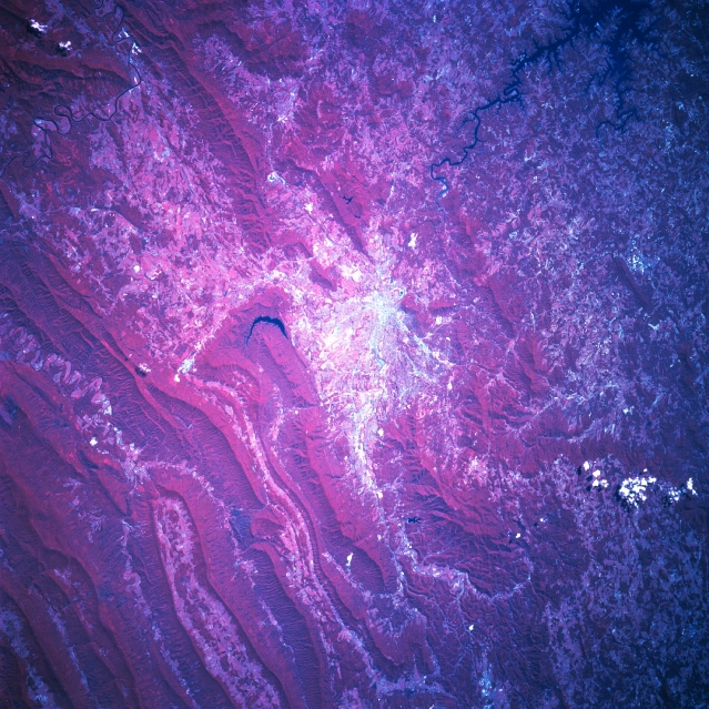 |
| STS078-760-004 Roanoke Area, Virginia, USA June 1996 Situated among outlying hills and the more massive folded, parallel ridge and valleys of the Appalachian Mountains, the physical setting of the city of Roanoke (highly reflective area center of the picture) is captured in this south looking color infrared shot. The dense green foliage of the mountainous terrain is shown as a deep reddish color. Most of the lower and flatter valleys are used for some form of agriculture. A single, dark, crescent-shaped reservoir within a small, elevated valley is just northwest of Roanoke. The Roanoke River meanders southeasterly from the city towards Smith Mountain Lake. |
| Images: | All Available Images Low-Resolution 405k |
|
| Mission: | STS078 |
|
| Roll - Frame: | 760 - 4 |
|
| Geographical Name: | USA-VIRGINIA |
|
| Features: | ROANOKE, ALLEGHENY MTS. |
|
| Center Lat x Lon: | 37.5N x 80W |
|
| Film Exposure: | N | N=Normal exposure, U=Under exposed, O=Over exposed, F=out of Focus |
| Percentage of Cloud Cover-CLDP: | 0 |
|
| Camera:: | HB |
|
| Camera Tilt: | 29 | LO=Low Oblique, HO=High Oblique, NV=Near Vertical |
| Camera Focal Length: | 250 |
|
| Nadir to Photo Center Direction: | S | The direction from the nadir to the center point, N=North, S=South, E=East, W=West |
| Stereo?: | N | Y=Yes there is an adjacent picture of the same area, N=No there isn't |
| Orbit Number: | 129 |
|
| Date: | 19960628 | YYYYMMDD |
| Time: | 143907 | GMT HHMMSS |
| Nadir Lat: | 38.7N |
Latitude of suborbital point of spacecraft |
| Nadir Lon: | 79.5W |
Longitude of suborbital point of spacecraft |
| Sun Azimuth: | 102 | Clockwise angle in degrees from north to the sun measured at the nadir point |
| Space Craft Altitude: | 143 | nautical miles |
| Sun Elevation: | 52 | Angle in degrees between the horizon and the sun, measured at the nadir point |
| Land Views: | MOUNTAIN, VALLEY, FOREST |
|
| Water Views: | RIVER, LAKE |
|
| Atmosphere Views: | |
|
| Man Made Views: | |
|
| City Views: | |
|
Photo is not associated with any sequences | ||
| NASA Home Page |
JSC Home Page |
JSC Digital Image Collection |
Earth Science & Remote Sensing |
|
This service is provided by the International Space Station program and the JSC Earth Science & Remote Sensing Unit, ARES Division, Exploration Integration Science Directorate.

|