
Geographic Region: USA-ILLINOIS
Feature: ILLINOIS & MISSISSIPPI R
|
Geographic Region: USA-ILLINOIS Feature: ILLINOIS & MISSISSIPPI R |
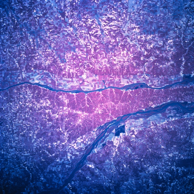 |
| STS078-758-94 Illinois/Mississippi Rivers, Illinois, USA June 1996 The largest cultivated field patterns on this color infrared image are visible on the narrow floodplains of the Illinois River (narrower, straighter river in the center of the view) and the Mississippi River (broader and slightly curving river west of the Illinois River). Most of the picture shows smaller, angular agricultural field patterns (in red, pink, and white) concentrated within red-mauve areas that represent the green, forested lands on infrared film. The land between these two south flowing rivers tapers into a peninsula, just north of where the Illinois River joins the Mississippi River (slightly northwest of St. Louis--not in this image). The peninsula is more heavily forested (concentration of reds indicate green woodlands) and less broken up by fields, perhaps because it is more remote from cities and transport routes. Mark Twain Wildlife Refuge is also in the area. The stream channels for several west flowing tributary streams that feed the Illinois River can be traced across the landscape to their entry point into the Illinois River. |
| Images: | All Available Images Low-Resolution 438k |
|
| Mission: | STS078 |
|
| Roll - Frame: | 758 - 94 |
|
| Geographical Name: | USA-ILLINOIS |
|
| Features: | ILLINOIS & MISSISSIPPI R |
|
| Center Lat x Lon: | 39.5N x 90.5W |
|
| Film Exposure: | N | N=Normal exposure, U=Under exposed, O=Over exposed, F=out of Focus |
| Percentage of Cloud Cover-CLDP: | 0 |
|
| Camera:: | HB |
|
| Camera Tilt: | 29 | LO=Low Oblique, HO=High Oblique, NV=Near Vertical |
| Camera Focal Length: | 250 |
|
| Nadir to Photo Center Direction: | W | The direction from the nadir to the center point, N=North, S=South, E=East, W=West |
| Stereo?: | N | Y=Yes there is an adjacent picture of the same area, N=No there isn't |
| Orbit Number: | 129 |
|
| Date: | 19960628 | YYYYMMDD |
| Time: | 143702 | GMT HHMMSS |
| Nadir Lat: | 39.2N |
Latitude of suborbital point of spacecraft |
| Nadir Lon: | 89.2W |
Longitude of suborbital point of spacecraft |
| Sun Azimuth: | 95 | Clockwise angle in degrees from north to the sun measured at the nadir point |
| Space Craft Altitude: | 142 | nautical miles |
| Sun Elevation: | 44 | Angle in degrees between the horizon and the sun, measured at the nadir point |
| Land Views: | FLOOD PLAIN, FOREST |
|
| Water Views: | RIVER |
|
| Atmosphere Views: | |
|
| Man Made Views: | AGRICULTURE |
|
| City Views: | |
|
Photo is not associated with any sequences | ||
| NASA Home Page |
JSC Home Page |
JSC Digital Image Collection |
Earth Science & Remote Sensing |
|
This service is provided by the International Space Station program and the JSC Earth Science & Remote Sensing Unit, ARES Division, Exploration Integration Science Directorate.

|