
Geographic Region: USA-NORTH CAROLINA
Feature: PAMLICO SOUND,LAKE, SED.
|
Geographic Region: USA-NORTH CAROLINA Feature: PAMLICO SOUND,LAKE, SED. |
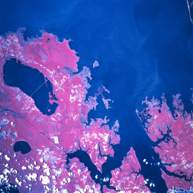 |
| STS078-758-048 Pamlico Sound, North Carolina, USA June 1996 Pamlico Sound, partly visible in this near vertical picture, is a large inlet (dark blue feature) of the Atlantic Ocean that is located along the east coast of North Carolina. The wide mouth of the Pamlico River and the Pungo Estuary are visible near the western edge of the image. The color infrared quality (green vegetation is shown as reddish colors/hues) accentuates landscape features and also helps to map changes in the land-water boundary. The ability to discriminate cultivated field patterns is also enhanced by the color infrared image. Several specific features can be identified: Lake Mattamuskeet (large dark body of water--bottom middle) which is a National Wildlife Refuge and a state highway bridge that crosses the lake; Alligator Lake (smaller, roughly oval-shaped dark feature--bottom right); and the Alligator-Pungo Canal (dark, linear feature--bottom right). A few cumulus clouds (lower right corner) are not to be confused with the lighter-colored cultivated fields (angular patterns). |
| Images: | All Available Images Low-Resolution 352k |
|
| Mission: | STS078 |
|
| Roll - Frame: | 758 - 48 |
|
| Geographical Name: | USA-NORTH CAROLINA |
|
| Features: | PAMLICO SOUND,LAKE, SED. |
|
| Center Lat x Lon: | 35.5N x 76W |
|
| Film Exposure: | N | N=Normal exposure, U=Under exposed, O=Over exposed, F=out of Focus |
| Percentage of Cloud Cover-CLDP: | 10 |
|
| Camera:: | HB |
|
| Camera Tilt: | 16 | LO=Low Oblique, HO=High Oblique, NV=Near Vertical |
| Camera Focal Length: | 250 |
|
| Nadir to Photo Center Direction: | N | The direction from the nadir to the center point, N=North, S=South, E=East, W=West |
| Stereo?: | N | Y=Yes there is an adjacent picture of the same area, N=No there isn't |
| Orbit Number: | 114 |
|
| Date: | 19960627 | YYYYMMDD |
| Time: | 161712 | GMT HHMMSS |
| Nadir Lat: | 34.8N |
Latitude of suborbital point of spacecraft |
| Nadir Lon: | 76.1W |
Longitude of suborbital point of spacecraft |
| Sun Azimuth: | 133 | Clockwise angle in degrees from north to the sun measured at the nadir point |
| Space Craft Altitude: | 144 | nautical miles |
| Sun Elevation: | 74 | Angle in degrees between the horizon and the sun, measured at the nadir point |
| Land Views: | COAST, FOREST |
|
| Water Views: | CANAL, ESTUARY, SWAMP, LAKE |
|
| Atmosphere Views: | |
|
| Man Made Views: | AGRICULTURE |
|
| City Views: | |
|
Photo is not associated with any sequences | ||
| NASA Home Page |
JSC Home Page |
JSC Digital Image Collection |
Earth Science & Remote Sensing |
|
This service is provided by the International Space Station program and the JSC Earth Science & Remote Sensing Unit, ARES Division, Exploration Integration Science Directorate.

|