
Geographic Region: SICILY
Feature: MOUNT ETNA,PLUME,CATANIA
|
Geographic Region: SICILY Feature: MOUNT ETNA,PLUME,CATANIA |
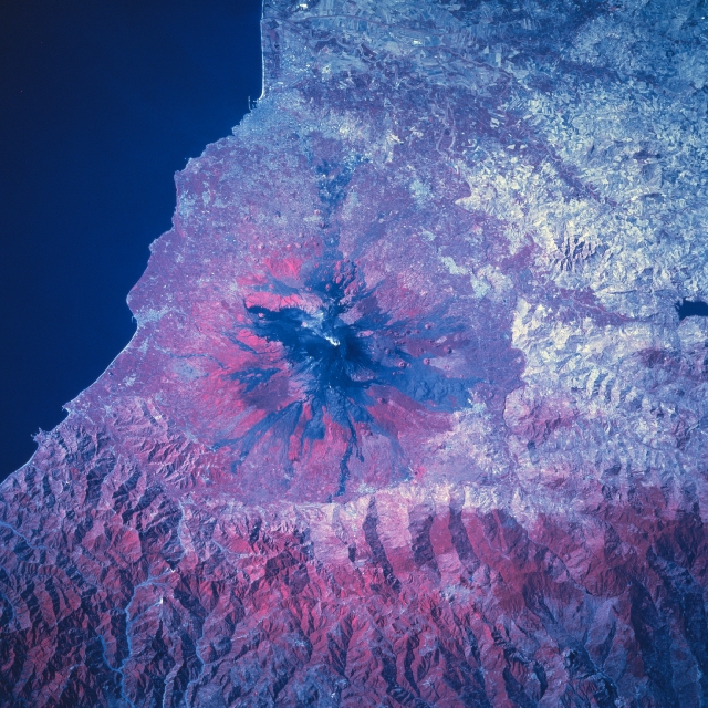 |
| STS078-755-39 Mt. Etna, Sicily, Italy June 1996 Located near the middle of the east coast of Sicily, Mt. Etna is a very active and thoroughly studied volcano. Since several towns and villages ring the base of the volcano the activity level of this shield volcano is constantly and carefully monitored. Compare the colors of this color infrared picture with STS78-737-50, a natural color image of Mt. Etna. The dark surface area on the flanks of the volcano on the color infrared image shows recent lava flows (the darkest are the most recent flows) and the reddish colors on the flanks shows the development of vegetative cover (green vegetation). On the natural color picture the dark slopes of the volcano indicate vegetation while the lava flows are lighter in appearance. The extensive, rugged mountainous landscape north of the volcano shows vegetation on most of the slopes; however, there is evidence (lighter-colored landscape) that a lumbering (clear-cutting) operation is reducing the forested lands in the mountains to the north. The dark features west of Mt. Etna are small reservoirs. |
| Images: | All Available Images Low-Resolution 392k |
|
| Mission: | STS078 |
|
| Roll - Frame: | 755 - 39 |
|
| Geographical Name: | SICILY |
|
| Features: | MOUNT ETNA,PLUME,CATANIA |
|
| Center Lat x Lon: | 37.5N x 15.0E |
|
| Film Exposure: | N | N=Normal exposure, U=Under exposed, O=Over exposed, F=out of Focus |
| Percentage of Cloud Cover-CLDP: | 0 |
|
| Camera:: | HB |
|
| Camera Tilt: | 35 | LO=Low Oblique, HO=High Oblique, NV=Near Vertical |
| Camera Focal Length: | 250 |
|
| Nadir to Photo Center Direction: | S | The direction from the nadir to the center point, N=North, S=South, E=East, W=West |
| Stereo?: | Y | Y=Yes there is an adjacent picture of the same area, N=No there isn't |
| Orbit Number: | 156 |
|
| Date: | 19960630 | YYYYMMDD |
| Time: | 070000 | GMT HHMMSS |
| Nadir Lat: | 39.1N |
Latitude of suborbital point of spacecraft |
| Nadir Lon: | 15.4E |
Longitude of suborbital point of spacecraft |
| Sun Azimuth: | 88 | Clockwise angle in degrees from north to the sun measured at the nadir point |
| Space Craft Altitude: | 141 | nautical miles |
| Sun Elevation: | 37 | Angle in degrees between the horizon and the sun, measured at the nadir point |
| Land Views: | VOLCANO |
|
| Water Views: | |
|
| Atmosphere Views: | |
|
| Man Made Views: | |
|
| City Views: | |
|
Photo is not associated with any sequences | ||
| NASA Home Page |
JSC Home Page |
JSC Digital Image Collection |
Earth Science & Remote Sensing |
|
This service is provided by the International Space Station program and the JSC Earth Science & Remote Sensing Unit, ARES Division, Exploration Integration Science Directorate.

|