
Geographic Region: USA-TENNESSEE
Feature: MEMPHIS, MISSISSIPPI R.
|
Geographic Region: USA-TENNESSEE Feature: MEMPHIS, MISSISSIPPI R. |
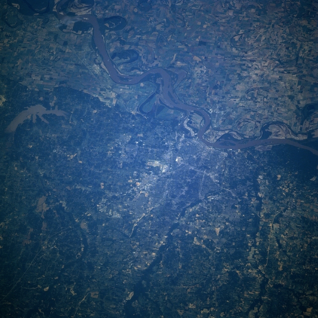 |
| STS078-754-079 Mississippi River, Memphis, Tennessee June, 1996 One of the leading cities of the American south and a major river port on the Mississippi River, the city of Memphis is visible in this west-looking view. The Mississippi, the third largest river system in the world, traverses the image from the center right (north) to the upper left (south-southwest). Memphis is located on Chickasaw Bluff on the Mississippi River's east bank. The city was established in 1819 and given its name by Andrew Jackson. The runways of Memphis International Airport are discernible near the center of the image. Midway between the center left and upper left of the image are the silted waters of Lake Arkabotla in northwestern Mississippi. The intensive agricultural fields of the Mississippi River Floodplain in eastern Arkansas can be seen in the upper right portion of the image. |
| Images: | All Available Images Low-Resolution 355k |
|
| Mission: | STS078 |
|
| Roll - Frame: | 754 - 79 |
|
| Geographical Name: | USA-TENNESSEE |
|
| Features: | MEMPHIS, MISSISSIPPI R. |
|
| Center Lat x Lon: | 35.0N x 90W |
|
| Film Exposure: | N | N=Normal exposure, U=Under exposed, O=Over exposed, F=out of Focus |
| Percentage of Cloud Cover-CLDP: | 0 |
|
| Camera:: | HB |
|
| Camera Tilt: | 43 | LO=Low Oblique, HO=High Oblique, NV=Near Vertical |
| Camera Focal Length: | 250 |
|
| Nadir to Photo Center Direction: | W | The direction from the nadir to the center point, N=North, S=South, E=East, W=West |
| Stereo?: | N | Y=Yes there is an adjacent picture of the same area, N=No there isn't |
| Orbit Number: | 112 |
|
| Date: | 19960627 | YYYYMMDD |
| Time: | 130533 | GMT HHMMSS |
| Nadir Lat: | 35.5N |
Latitude of suborbital point of spacecraft |
| Nadir Lon: | 87.8W |
Longitude of suborbital point of spacecraft |
| Sun Azimuth: | 80 | Clockwise angle in degrees from north to the sun measured at the nadir point |
| Space Craft Altitude: | 143 | nautical miles |
| Sun Elevation: | 27 | Angle in degrees between the horizon and the sun, measured at the nadir point |
| Land Views: | PLAIN |
|
| Water Views: | RIVER, LAKE, SEDIMENT |
|
| Atmosphere Views: | |
|
| Man Made Views: | AGRICULTURE, URBAN AREA, AIRPORT |
|
| City Views: | MEMPHIS |
|
Photo is not associated with any sequences | ||
| NASA Home Page |
JSC Home Page |
JSC Digital Image Collection |
Earth Science & Remote Sensing |
|
This service is provided by the International Space Station program and the JSC Earth Science & Remote Sensing Unit, ARES Division, Exploration Integration Science Directorate.

|