
Geographic Region: SAUDI ARABIA
Feature: PIVOT AGRICULTURE
|
Geographic Region: SAUDI ARABIA Feature: PIVOT AGRICULTURE |
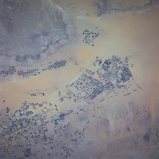 |
| STS078-754-047 Desert Farming, Saudi Arabia June 1996 The bright reflectance of sand and gravel serves as a background for the multitude of center pivot irrigated fields (circular features) in this desert region of southwest Saudi Arabia. This dry land farming technique is used extensively in several parts of arid Saudi Arabia. The circles are generally a kilometer in diameter and the intensively irrigated fields are used primarily for growing wheat and other cereal grains. Notice that many circular fields look faded indicating that they have not been replanted (either fallowing or taken out of production entirely), or the fields have only recently been replanted. Some of the fields also show that only parts of the fields (donut-shaped, semicircles) are currently being used for agriculture. The slightly elevated terrain near the bottom of the image with the entrenched stream drainage patterns (from formerly wetter times) is part of the Tuway Mountains. The thin, dark-looking western edge of the low mountainous terrain is a well-defined north-south oriented escarpment. Immediately adjacent to the west-facing escarpment, wadis (dry stream beds or watercourses) parallel the steep cliffs. Wadi al Hinw (bottom center) is the single east/west corridor through the escarpment. |
| Images: | All Available Images Low-Resolution 341k |
|
| Mission: | STS078 |
|
| Roll - Frame: | 754 - 47 |
|
| Geographical Name: | SAUDI ARABIA |
|
| Features: | PIVOT AGRICULTURE |
|
| Center Lat x Lon: | 20.5N x 45.0E |
|
| Film Exposure: | N | N=Normal exposure, U=Under exposed, O=Over exposed, F=out of Focus |
| Percentage of Cloud Cover-CLDP: | 0 |
|
| Camera:: | HB |
|
| Camera Tilt: | NV | LO=Low Oblique, HO=High Oblique, NV=Near Vertical |
| Camera Focal Length: | 250 |
|
| Nadir to Photo Center Direction: | NW | The direction from the nadir to the center point, N=North, S=South, E=East, W=West |
| Stereo?: | Y | Y=Yes there is an adjacent picture of the same area, N=No there isn't |
| Orbit Number: | 110 |
|
| Date: | 19960627 | YYYYMMDD |
| Time: | 102627 | GMT HHMMSS |
| Nadir Lat: | 19.3N |
Latitude of suborbital point of spacecraft |
| Nadir Lon: | 46.4E |
Longitude of suborbital point of spacecraft |
| Sun Azimuth: | 285 | Clockwise angle in degrees from north to the sun measured at the nadir point |
| Space Craft Altitude: | 146 | nautical miles |
| Sun Elevation: | 69 | Angle in degrees between the horizon and the sun, measured at the nadir point |
| Land Views: | DESERT, ESCARPMENT |
|
| Water Views: | |
|
| Atmosphere Views: | |
|
| Man Made Views: | AGRICULTURE |
|
| City Views: | |
|
Photo is not associated with any sequences | ||
| NASA Home Page |
JSC Home Page |
JSC Digital Image Collection |
Earth Science & Remote Sensing |
|
This service is provided by the International Space Station program and the JSC Earth Science & Remote Sensing Unit, ARES Division, Exploration Integration Science Directorate.

|