
Geographic Region: SAUDI ARABIA
Feature: AL JUBAYL, ROADS, JETTYS
|
Geographic Region: SAUDI ARABIA Feature: AL JUBAYL, ROADS, JETTYS |
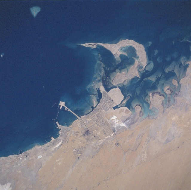 |
| STS078-748-007 Al Jubayl (Jubail), Saudi Arabia June 1996 The water (dark area) of the Persian Gulf contrasts with the sandy, desert landscape of the northeast coast of Saudi Arabia. This newly created (development started in the 1980s) industrial center of Al Jabayl (also knows as Jubail), a city with modern infrastructure, is located in the middle of the image. The infrastructure includes modern residential areas, petrochemical plants, iron works, airport (southeast of the city), highways, railroad, and port facilities - plus the Royal Saudi Naval Base (located south of the industrial port facilities - see long piers and breakwater). The lighter colored, undeveloped areas scattered throughout the coastal region are dry lakebeds (salt flats). The thin dark line inland but parallel to the coast (upper right quadrant) is a combination highway and pipeline right of way. |
| Images: | All Available Images Low-Resolution 320k |
|
| Mission: | STS078 |
|
| Roll - Frame: | 748 - 7 |
|
| Geographical Name: | SAUDI ARABIA |
|
| Features: | AL JUBAYL, ROADS, JETTYS |
|
| Center Lat x Lon: | 27.0N x 49.5E |
|
| Film Exposure: | N | N=Normal exposure, U=Under exposed, O=Over exposed, F=out of Focus |
| Percentage of Cloud Cover-CLDP: | 0 |
|
| Camera:: | HB |
|
| Camera Tilt: | 21 | LO=Low Oblique, HO=High Oblique, NV=Near Vertical |
| Camera Focal Length: | 250 |
|
| Nadir to Photo Center Direction: | NE | The direction from the nadir to the center point, N=North, S=South, E=East, W=West |
| Stereo?: | Y | Y=Yes there is an adjacent picture of the same area, N=No there isn't |
| Orbit Number: | 78 |
|
| Date: | 19960625 | YYYYMMDD |
| Time: | 103044 | GMT HHMMSS |
| Nadir Lat: | 26.2N |
Latitude of suborbital point of spacecraft |
| Nadir Lon: | 49.0E |
Longitude of suborbital point of spacecraft |
| Sun Azimuth: | 269 | Clockwise angle in degrees from north to the sun measured at the nadir point |
| Space Craft Altitude: | 146 | nautical miles |
| Sun Elevation: | 66 | Angle in degrees between the horizon and the sun, measured at the nadir point |
| Land Views: | DESERT |
|
| Water Views: | GULF |
|
| Atmosphere Views: | |
|
| Man Made Views: | URBAN AREA, PORT |
|
| City Views: | AL JUBAYL |
|
Photo is not associated with any sequences | ||
| NASA Home Page |
JSC Home Page |
JSC Digital Image Collection |
Earth Science & Remote Sensing |
|
This service is provided by the International Space Station program and the JSC Earth Science & Remote Sensing Unit, ARES Division, Exploration Integration Science Directorate.

|