
Geographic Region: TURKEY
Feature: ATATURK RES.,SNGLNT.,AGR
|
Geographic Region: TURKEY Feature: ATATURK RES.,SNGLNT.,AGR |
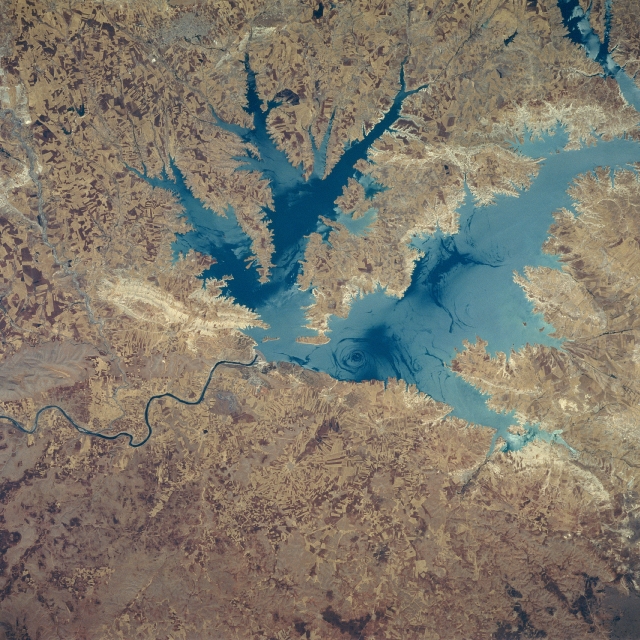 |
| STS078-747-81 Ataturk Reservoir, Turkey June 1996 This northeast-looking view shows the Ataturk Reservoir and Dam, presently the largest man-made lake in Turkey. Located in south central Turkey on the Euphrates River, Ataturk Reservoir was completed in the early 1990's. The meandering Euphrates River (dark line) can be seen exiting the scene below the left center of the image. This particular image was acquired with the waters of the reservoir at the edge of the sun's reflection or sun glitter (Reference STS078-747-80). In the middle of the sun's reflection, the surface waters appear lighter in color, especially if the surface is smooth. In this image the smooth waters appear as dark blue, and roughened waters appearing as a light blue color. Several eddies are visible on the water's surface. Because of this and other dams north of the Ataturk Reservoir, water flow of the Euphrates River has been reduced causing political problems for Turkey's neighbors to the south (Syria and Iraq). Discussions between the three countries to reach an agreeable solution to the problem are ongoing. Numerous angular field patterns can be seen throughout the image. The highly reflective surface area immediately to the west of the dam (left center of the image) appears to be an area where quarried rocks were used for the construction of the dam. |
| Images: | All Available Images Low-Resolution 396k |
|
| Mission: | STS078 |
|
| Roll - Frame: | 747 - 81 |
|
| Geographical Name: | TURKEY |
|
| Features: | ATATURK RES.,SNGLNT.,AGR |
|
| Center Lat x Lon: | 37.5N x 38.5E |
|
| Film Exposure: | N | N=Normal exposure, U=Under exposed, O=Over exposed, F=out of Focus |
| Percentage of Cloud Cover-CLDP: | 0 |
|
| Camera:: | HB |
|
| Camera Tilt: | 8 | LO=Low Oblique, HO=High Oblique, NV=Near Vertical |
| Camera Focal Length: | 250 |
|
| Nadir to Photo Center Direction: | SW | The direction from the nadir to the center point, N=North, S=South, E=East, W=West |
| Stereo?: | N | Y=Yes there is an adjacent picture of the same area, N=No there isn't |
| Orbit Number: | 77 |
|
| Date: | 19960625 | YYYYMMDD |
| Time: | 085300 | GMT HHMMSS |
| Nadir Lat: | 37.8N |
Latitude of suborbital point of spacecraft |
| Nadir Lon: | 38.7E |
Longitude of suborbital point of spacecraft |
| Sun Azimuth: | 150 | Clockwise angle in degrees from north to the sun measured at the nadir point |
| Space Craft Altitude: | 145 | nautical miles |
| Sun Elevation: | 74 | Angle in degrees between the horizon and the sun, measured at the nadir point |
| Land Views: | HILL |
|
| Water Views: | SUNGLINT, RESERVOIR, EDDY, RIVER |
|
| Atmosphere Views: | |
|
| Man Made Views: | DAM, AGRICULTURE |
|
| City Views: | |
|
Photo is not associated with any sequences | ||
| NASA Home Page |
JSC Home Page |
JSC Digital Image Collection |
Earth Science & Remote Sensing |
|
This service is provided by the International Space Station program and the JSC Earth Science & Remote Sensing Unit, ARES Division, Exploration Integration Science Directorate.

|