
Geographic Region: USA-MISSOURI
Feature: OH. & MS. R.,AGR.,BARGES
|
Geographic Region: USA-MISSOURI Feature: OH. & MS. R.,AGR.,BARGES |
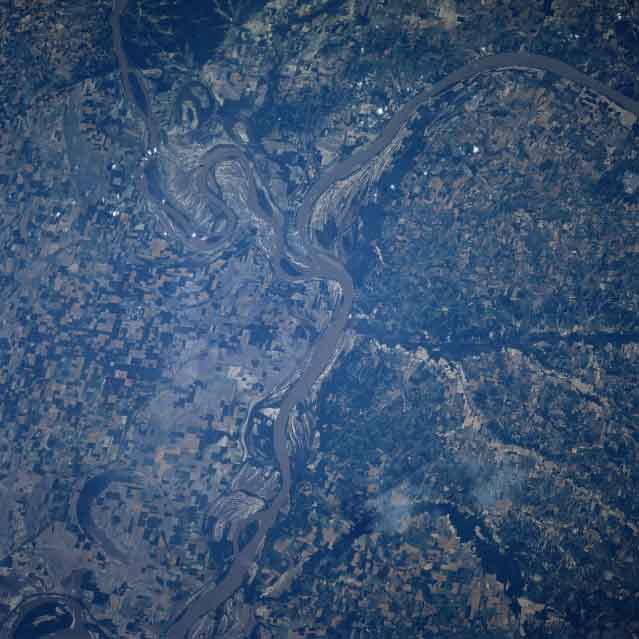 |
| STS078-747-004 Mississippi and Ohio Rivers, Missouri June, 1996 The Ohio River enters the Mississippi River near the center of this image with its north-looking low-oblique view. The Ohio River enters from the east in the upper right portion of the scene, while the Mississippi River enters from the north in the upper left and flows generally southward, exiting in the lower left portion of the image. In terms of water volume, the Ohio is the largest tributary of Mississippi River. Portions of the Missouri Boot Heel, a fertile agricultural area, are visible to the west (left) of the Mississippi River. The low, gently rolling terrain of Western Kentucky comprises the east (right) of the Mississippi River. At the extreme bottom left, and barely discernible on the image, is the small city of New Madrid, Missouri. |
| Images: | All Available Images Low-Resolution 42k |
|
| Mission: | STS078 |
|
| Roll - Frame: | 747 - 4 |
|
| Geographical Name: | USA-MISSOURI |
|
| Features: | OH. & MS. R.,AGR.,BARGES |
|
| Center Lat x Lon: | 37.0N x 89W |
|
| Film Exposure: | N | N=Normal exposure, U=Under exposed, O=Over exposed, F=out of Focus |
| Percentage of Cloud Cover-CLDP: | 0 |
|
| Camera:: | HB |
|
| Camera Tilt: | 27 | LO=Low Oblique, HO=High Oblique, NV=Near Vertical |
| Camera Focal Length: | 250 |
|
| Nadir to Photo Center Direction: | NW | The direction from the nadir to the center point, N=North, S=South, E=East, W=West |
| Stereo?: | N | Y=Yes there is an adjacent picture of the same area, N=No there isn't |
| Orbit Number: | 65 |
|
| Date: | 19960624 | YYYYMMDD |
| Time: | 144654 | GMT HHMMSS |
| Nadir Lat: | 36.0N |
Latitude of suborbital point of spacecraft |
| Nadir Lon: | 88.3W |
Longitude of suborbital point of spacecraft |
| Sun Azimuth: | 94 | Clockwise angle in degrees from north to the sun measured at the nadir point |
| Space Craft Altitude: | 144 | nautical miles |
| Sun Elevation: | 48 | Angle in degrees between the horizon and the sun, measured at the nadir point |
| Land Views: | PLAIN |
|
| Water Views: | RIVER |
|
| Atmosphere Views: | |
|
| Man Made Views: | AGRICULTURE |
|
| City Views: | |
|
Photo is not associated with any sequences | ||
| NASA Home Page |
JSC Home Page |
JSC Digital Image Collection |
Earth Science & Remote Sensing |
|
This service is provided by the International Space Station program and the JSC Earth Science & Remote Sensing Unit, ARES Division, Exploration Integration Science Directorate.

|