
Geographic Region: GREECE
Feature: ZAKINTHOS I., CITY,ROADS
|
Geographic Region: GREECE Feature: ZAKINTHOS I., CITY,ROADS |
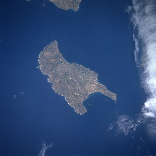 |
| STS078-743-076 Zakinthos Island, Greece June 1996 Located in the Ionian Sea off the west coast of Greece, Zakinthos Island can be seen in this near-nadir view. Zakinthos Island is 25 miles (40 km) long, 12 miles (19 km) wide and covers an area of 157 sq. miles (407 sq. km). The island has a wide fertile plain in its central part with low hills to the west. Wine, currants, citrus fruits, and olive oil are produced on this intensively cultivated island. Zakinthos Island is subject to frequent earthquakes. |
| Images: | All Available Images Low-Resolution 240k |
|
| Mission: | STS078 |
|
| Roll - Frame: | 743 - 76 |
|
| Geographical Name: | GREECE |
|
| Features: | ZAKINTHOS I., CITY,ROADS |
|
| Center Lat x Lon: | 38.0N x 21.0E |
|
| Film Exposure: | N | N=Normal exposure, U=Under exposed, O=Over exposed, F=out of Focus |
| Percentage of Cloud Cover-CLDP: | 5 |
|
| Camera:: | HB |
|
| Camera Tilt: | 27 | LO=Low Oblique, HO=High Oblique, NV=Near Vertical |
| Camera Focal Length: | 250 |
|
| Nadir to Photo Center Direction: | N | The direction from the nadir to the center point, N=North, S=South, E=East, W=West |
| Stereo?: | Y | Y=Yes there is an adjacent picture of the same area, N=No there isn't |
| Orbit Number: | 78 |
|
| Date: | 19960625 | YYYYMMDD |
| Time: | 102357 | GMT HHMMSS |
| Nadir Lat: | 36.8N |
Latitude of suborbital point of spacecraft |
| Nadir Lon: | 21.3E |
Longitude of suborbital point of spacecraft |
| Sun Azimuth: | 167 | Clockwise angle in degrees from north to the sun measured at the nadir point |
| Space Craft Altitude: | 145 | nautical miles |
| Sun Elevation: | 76 | Angle in degrees between the horizon and the sun, measured at the nadir point |
| Land Views: | ISLAND, COAST, HILL, PLAIN |
|
| Water Views: | |
|
| Atmosphere Views: | |
|
| Man Made Views: | |
|
| City Views: | |
|
Photo is not associated with any sequences | ||
| NASA Home Page |
JSC Home Page |
JSC Digital Image Collection |
Earth Science & Remote Sensing |
|
This service is provided by the International Space Station program and the JSC Earth Science & Remote Sensing Unit, ARES Division, Exploration Integration Science Directorate.

|