Geographic Region: INDONESIA-B
Feature: COAST,DJULAI & AIRHITAM R
|
Geographic Region: INDONESIA-B Feature: COAST,DJULAI & AIRHITAM R |
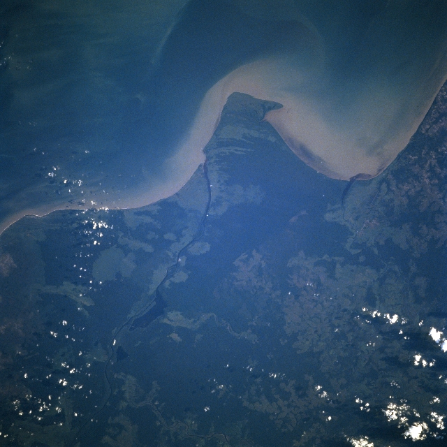 |
| STS078-743-044 Djulai River, West Kalimantan, Indonesia June 1996 The Djulai River (thin, dark line) is the border between West (Barat) Kalimantan (area northwest of river) and Central (Tengah) Kalimantan along the southwest coast of this Indonesian Island. The Djulai River empties into the Java Sea just east of a small peninsula (bottom center). The Airhtam River (more difficult to identify) is also visible as it empties into Airhtam Bay, west of the small peninsula. The longshore current is transporting a band of sediment (lighter-colored water) westward into Airhtam Bay. While most of the landscape is low-lying swampy wetlands, the darker areas show stands of tropical rainforests. The only evidence of development in this remote region of West Kalimantan is in areas (lighter color) where the dense forest cover has been removed. |
| Images: | All Available Images Low-Resolution 311k |
|
| Mission: | STS078 |
|
| Roll - Frame: | 743 - 44 |
|
| Geographical Name: | INDONESIA-B |
|
| Features: | COAST,DJULAI & AIRHITAM R |
|
| Center Lat x Lon: | 3S x 110.5E |
|
| Film Exposure: | N | N=Normal exposure, U=Under exposed, O=Over exposed, F=out of Focus |
| Percentage of Cloud Cover-CLDP: | 5 |
|
| Camera:: | HB |
|
| Camera Tilt: | 18 | LO=Low Oblique, HO=High Oblique, NV=Near Vertical |
| Camera Focal Length: | 250 |
|
| Nadir to Photo Center Direction: | N | The direction from the nadir to the center point, N=North, S=South, E=East, W=West |
| Stereo?: | Y | Y=Yes there is an adjacent picture of the same area, N=No there isn't |
| Orbit Number: | 77 |
|
| Date: | 19960625 | YYYYMMDD |
| Time: | 091330 | GMT HHMMSS |
| Nadir Lat: | 3.8S |
Latitude of suborbital point of spacecraft |
| Nadir Lon: | 110.6E |
Longitude of suborbital point of spacecraft |
| Sun Azimuth: | 296 | Clockwise angle in degrees from north to the sun measured at the nadir point |
| Space Craft Altitude: | 147 | nautical miles |
| Sun Elevation: | 18 | Angle in degrees between the horizon and the sun, measured at the nadir point |
| Land Views: | FOREST |
|
| Water Views: | RIVER, SEDIMENT, SWAMP |
|
| Atmosphere Views: | |
|
| Man Made Views: | |
|
| City Views: | |
|
Photo is not associated with any sequences | ||
| NASA Home Page |
JSC Home Page |
JSC Digital Image Collection |
Earth Science & Remote Sensing |
|
This service is provided by the International Space Station program and the JSC Earth Science & Remote Sensing Unit, ARES Division, Exploration Integration Science Directorate.

|