
Geographic Region: IRAQ
Feature: BAGHDAD, TIGRIS R., AGR.
|
Geographic Region: IRAQ Feature: BAGHDAD, TIGRIS R., AGR. |
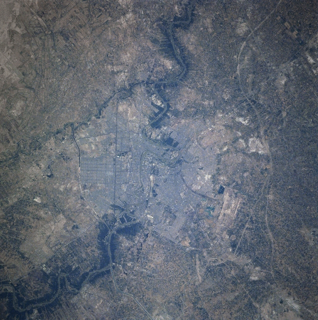 |
| STS078-740-087 Baghdad, Iraq June 1996 The capital city of Iraq, Baghdad, located in a broad plain with a population of nearly 4 million, can be seen in this near-nadir view. The Tigris River is visible entering the scene from the upper left (north) traversing south through the city, and exiting the scene at the right center of the image (south). Canals are discernible throughout the view traversing through and around the city. Even after the Gulf War of early 1991, Baghdad remains the major commercial and industrial center of the country. The runways of the Baghdad International Airport are visible midway between the center and the bottom of the image (west of the city center). |
| Images: | All Available Images Low-Resolution 393k |
|
| Mission: | STS078 |
|
| Roll - Frame: | 740 - 87 |
|
| Geographical Name: | IRAQ |
|
| Features: | BAGHDAD, TIGRIS R., AGR. |
|
| Center Lat x Lon: | 33.5N x 44.5E |
|
| Film Exposure: | N | N=Normal exposure, U=Under exposed, O=Over exposed, F=out of Focus |
| Percentage of Cloud Cover-CLDP: | 0 |
|
| Camera:: | HB |
|
| Camera Tilt: | 12 | LO=Low Oblique, HO=High Oblique, NV=Near Vertical |
| Camera Focal Length: | 250 |
|
| Nadir to Photo Center Direction: | NE | The direction from the nadir to the center point, N=North, S=South, E=East, W=West |
| Stereo?: | N | Y=Yes there is an adjacent picture of the same area, N=No there isn't |
| Orbit Number: | 219 |
|
| Date: | 19960704 | YYYYMMDD |
| Time: | 051452 | GMT HHMMSS |
| Nadir Lat: | 33.1N |
Latitude of suborbital point of spacecraft |
| Nadir Lon: | 44.2E |
Longitude of suborbital point of spacecraft |
| Sun Azimuth: | 86 | Clockwise angle in degrees from north to the sun measured at the nadir point |
| Space Craft Altitude: | 139 | nautical miles |
| Sun Elevation: | 38 | Angle in degrees between the horizon and the sun, measured at the nadir point |
| Land Views: | DESERT |
|
| Water Views: | RIVER, CHANNEL |
|
| Atmosphere Views: | |
|
| Man Made Views: | URBAN AREA, AGRICULTURE, AIRPORT, HIGHWAY |
|
| City Views: | BAGHDAD |
|
Photo is not associated with any sequences | ||
| NASA Home Page |
JSC Home Page |
JSC Digital Image Collection |
Earth Science & Remote Sensing |
|
This service is provided by the International Space Station program and the JSC Earth Science & Remote Sensing Unit, ARES Division, Exploration Integration Science Directorate.

|