
Geographic Region: SYRIA
Feature: ASSAD RES.,EUPHRATES,AGR
|
Geographic Region: SYRIA Feature: ASSAD RES.,EUPHRATES,AGR |
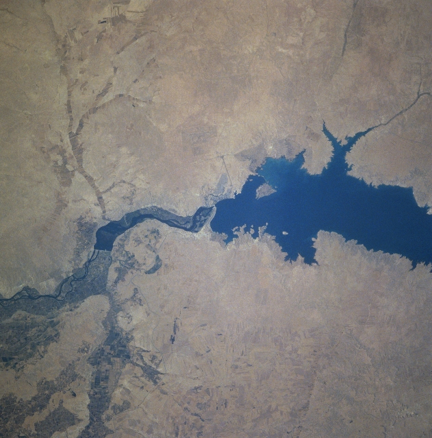 |
| STS078-740-083 Tabaqah Dam, Lake Assad, Syria June 1996 Completed in 1973, the Tabaqah Dam (center of image) on the Euphrates River can be seen in this near-nadir view. The Tabaqah Dam is an earth filled dam nearly 197 feet (60 meters) high and 3 miles (5 km) long. The dam holds the waters of Lake Assad (center to left center of the image), a 50-mile (80 km) long and 5-mile (8 km) wide reservoir. Lake Assad and the Tabaqah Dam have not only provided increased hydroelectric power but the lake has doubled Syria's irrigated land. Actual crop production has not reached the goals set by the Syrian government due to a number of problems including the gypsum subsoil of the region, and whether or not farmers could be attracted back to this scarsely populated area from urban areas or more crowded agricultural areas in other parts of the country. Also the water levels within Lake Assad remain low due mostly in part to construction of the Keban and Ataturk Dams in Turkey, which have reduced the water flow of the Euphrates River in Syria. |
| Images: | All Available Images Low-Resolution 328k |
|
| Mission: | STS078 |
|
| Roll - Frame: | 740 - 83 |
|
| Geographical Name: | SYRIA |
|
| Features: | ASSAD RES.,EUPHRATES,AGR |
|
| Center Lat x Lon: | 36.0N x 38.5E |
|
| Film Exposure: | N | N=Normal exposure, U=Under exposed, O=Over exposed, F=out of Focus |
| Percentage of Cloud Cover-CLDP: | 0 |
|
| Camera:: | HB |
|
| Camera Tilt: | 27 | LO=Low Oblique, HO=High Oblique, NV=Near Vertical |
| Camera Focal Length: | 250 |
|
| Nadir to Photo Center Direction: | N | The direction from the nadir to the center point, N=North, S=South, E=East, W=West |
| Stereo?: | N | Y=Yes there is an adjacent picture of the same area, N=No there isn't |
| Orbit Number: | 219 |
|
| Date: | 19960704 | YYYYMMDD |
| Time: | 051337 | GMT HHMMSS |
| Nadir Lat: | 34.9N |
Latitude of suborbital point of spacecraft |
| Nadir Lon: | 38.9E |
Longitude of suborbital point of spacecraft |
| Sun Azimuth: | 84 | Clockwise angle in degrees from north to the sun measured at the nadir point |
| Space Craft Altitude: | 139 | nautical miles |
| Sun Elevation: | 34 | Angle in degrees between the horizon and the sun, measured at the nadir point |
| Land Views: | DESERT |
|
| Water Views: | RIVER, LAKE |
|
| Atmosphere Views: | |
|
| Man Made Views: | DAM |
|
| City Views: | |
|
Photo is not associated with any sequences | ||
| NASA Home Page |
JSC Home Page |
JSC Digital Image Collection |
Earth Science & Remote Sensing |
|
This service is provided by the International Space Station program and the JSC Earth Science & Remote Sensing Unit, ARES Division, Exploration Integration Science Directorate.

|