
Geographic Region: GREECE
Feature: KHALKIS,PARNIS MTS.,AGR.
|
Geographic Region: GREECE Feature: KHALKIS,PARNIS MTS.,AGR. |
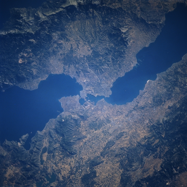 |
| STS078-740-066 Evripos Strait, Khalkis, Greece June 1996 The Evripos Strait, separating Evvoia Island (upper portion of the image) and the Greek mainland (bottom portion of the image) can be seen in this near-nadir view. The city of Khalkis is located at the northwestern end of the Evripos Strait on the island of Evvoia. A bridge (not discernible) connects Khalkis with the Greek mainland across the strait. Khalkis is the capital of the Evvoia Island prefecture. The city is a trade center for wine, cotton and citrus fruit. The great Greek Philosopher, Aristotle died here in 322 B.C. Evvoia Island is one of the largest of the Greek Islands and is mountainous with fertile valleys. Evvoia Island is 90 miles (145 km) long and between 4 miles (6 km) and 30 miles (48 km) wide and covers an area of 1467 sq. miles (3800 sq. km). Magnesite and lignite are mined, and marble is quarried on the island. |
| Images: | All Available Images Low-Resolution 354k |
|
| Mission: | STS078 |
|
| Roll - Frame: | 740 - 66 |
|
| Geographical Name: | GREECE |
|
| Features: | KHALKIS,PARNIS MTS.,AGR. |
|
| Center Lat x Lon: | 38.5N x 23.5E |
|
| Film Exposure: | N | N=Normal exposure, U=Under exposed, O=Over exposed, F=out of Focus |
| Percentage of Cloud Cover-CLDP: | 0 |
|
| Camera:: | HB |
|
| Camera Tilt: | 9 | LO=Low Oblique, HO=High Oblique, NV=Near Vertical |
| Camera Focal Length: | 250 |
|
| Nadir to Photo Center Direction: | NW | The direction from the nadir to the center point, N=North, S=South, E=East, W=West |
| Stereo?: | Y | Y=Yes there is an adjacent picture of the same area, N=No there isn't |
| Orbit Number: | 219 |
|
| Date: | 19960704 | YYYYMMDD |
| Time: | 051019 | GMT HHMMSS |
| Nadir Lat: | 38.2N |
Latitude of suborbital point of spacecraft |
| Nadir Lon: | 23.7E |
Longitude of suborbital point of spacecraft |
| Sun Azimuth: | 77 | Clockwise angle in degrees from north to the sun measured at the nadir point |
| Space Craft Altitude: | 138 | nautical miles |
| Sun Elevation: | 22 | Angle in degrees between the horizon and the sun, measured at the nadir point |
| Land Views: | MOUNTAIN, FOREST |
|
| Water Views: | STRAIT, GULF, BAY |
|
| Atmosphere Views: | |
|
| Man Made Views: | |
|
| City Views: | |
|
Photo is not associated with any sequences | ||
| NASA Home Page |
JSC Home Page |
JSC Digital Image Collection |
Earth Science & Remote Sensing |
|
This service is provided by the International Space Station program and the JSC Earth Science & Remote Sensing Unit, ARES Division, Exploration Integration Science Directorate.

|