
Geographic Region: SICILY
Feature: MOUNT ETNA,SMOKE,CATANIA
|
Geographic Region: SICILY Feature: MOUNT ETNA,SMOKE,CATANIA |
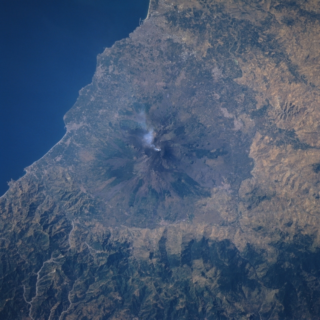 |
| STS078-737-050 Mt. Etna, Sicily, Italy June 1996 Mt. Etna, located in the center of the image, is one of the most active and most studied shield volcanoes in the world. The summit of Mt. Etna is 10991 feet (3350 meters) above sea level. Four small craters are located at the summit. Several cinder cones (generally circular-shaped features) are visible at various locations around the flanks of the volcano. The different colored terrain on the flanks of the volcano indicate lava flows that have occurred at different times and have produced a variety of surface roughness on the slopes of the volcano. One of the reasons that Mt. Etna is closely monitored is to provide advance warning of a major eruption to the surrounding towns and villages that are found around the base of the volcano. Notice that there is a small cloud coming from one of the craters in the summit area at the time this photograph was acquired (STS78-755-039 is a color infrared image of Mt. Etna). |
| Images: | All Available Images Low-Resolution 354k |
|
| Mission: | STS078 |
|
| Roll - Frame: | 737 - 50 |
|
| Geographical Name: | SICILY |
|
| Features: | MOUNT ETNA,SMOKE,CATANIA |
|
| Center Lat x Lon: | 38.0N x 15.0E |
|
| Film Exposure: | N | N=Normal exposure, U=Under exposed, O=Over exposed, F=out of Focus |
| Percentage of Cloud Cover-CLDP: | 0 |
|
| Camera:: | HB |
|
| Camera Tilt: | 17 | LO=Low Oblique, HO=High Oblique, NV=Near Vertical |
| Camera Focal Length: | 100 |
|
| Nadir to Photo Center Direction: | S | The direction from the nadir to the center point, N=North, S=South, E=East, W=West |
| Stereo?: | Y | Y=Yes there is an adjacent picture of the same area, N=No there isn't |
| Orbit Number: | 172 |
|
| Date: | 19960701 | YYYYMMDD |
| Time: | 065605 | GMT HHMMSS |
| Nadir Lat: | 38.7N |
Latitude of suborbital point of spacecraft |
| Nadir Lon: | 14.9E |
Longitude of suborbital point of spacecraft |
| Sun Azimuth: | 87 | Clockwise angle in degrees from north to the sun measured at the nadir point |
| Space Craft Altitude: | 140 | nautical miles |
| Sun Elevation: | 36 | Angle in degrees between the horizon and the sun, measured at the nadir point |
| Land Views: | VOLCANO |
|
| Water Views: | |
|
| Atmosphere Views: | PLUME |
|
| Man Made Views: | |
|
| City Views: | |
|
Photo is not associated with any sequences | ||
| NASA Home Page |
JSC Home Page |
JSC Digital Image Collection |
Earth Science & Remote Sensing |
|
This service is provided by the International Space Station program and the JSC Earth Science & Remote Sensing Unit, ARES Division, Exploration Integration Science Directorate.

|