
Geographic Region: BOLIVIA
Feature: LAKE COIPASA ,VOLCANOES
|
Geographic Region: BOLIVIA Feature: LAKE COIPASA ,VOLCANOES |
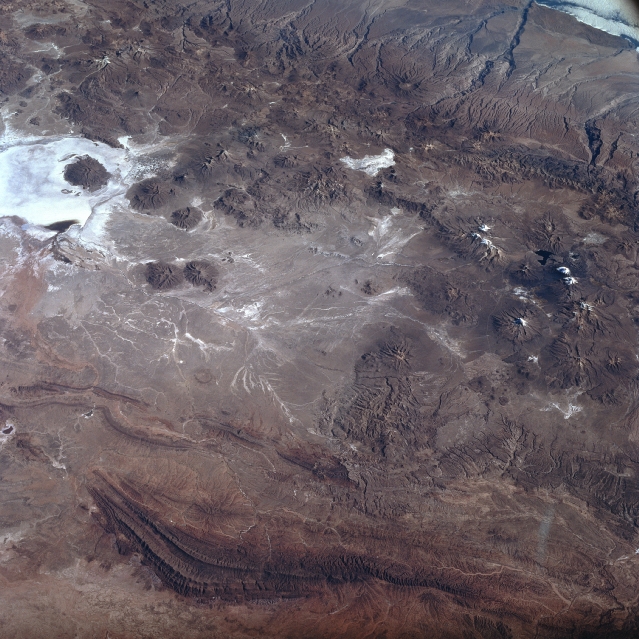 |
| STS078-737-014 Lake Coipasa, Bolivia June 1996 The most obvious landform in this southwest looking view of the Altiplano in southwest Bolivia is the highly reflective salt flat, Salar de Coipasa (upper left). There is a dendritic drainage pattern that connects to intermittently flowing stream channels north of the Salar de Coipasa. The darker, semi-circular features are volcanoes that generally trend north-south. The maximum elevation of the volcano located within Salar de Coipasa is 16149 feet (4922 meters) above sea level, while the elevation of the dry lake is 11985 feet (3653 meters). A series of paralleling folded mountains are visible near the bottom of the image. |
| Images: | All Available Images Low-Resolution 356k |
|
| Mission: | STS078 |
|
| Roll - Frame: | 737 - 14 |
|
| Geographical Name: | BOLIVIA |
|
| Features: | LAKE COIPASA ,VOLCANOES |
|
| Center Lat x Lon: | 18.5S x 68.5W |
|
| Film Exposure: | N | N=Normal exposure, U=Under exposed, O=Over exposed, F=out of Focus |
| Percentage of Cloud Cover-CLDP: | 10 |
|
| Camera:: | HB |
|
| Camera Tilt: | HO | LO=Low Oblique, HO=High Oblique, NV=Near Vertical |
| Camera Focal Length: | 100 |
|
| Nadir to Photo Center Direction: | SW | The direction from the nadir to the center point, N=North, S=South, E=East, W=West |
| Stereo?: | Y | Y=Yes there is an adjacent picture of the same area, N=No there isn't |
| Orbit Number: | 164 |
|
| Date: | 19960630 | YYYYMMDD |
| Time: | 192600 | GMT HHMMSS |
| Nadir Lat: | 17S |
Latitude of suborbital point of spacecraft |
| Nadir Lon: | 66.9W |
Longitude of suborbital point of spacecraft |
| Sun Azimuth: | 312 | Clockwise angle in degrees from north to the sun measured at the nadir point |
| Space Craft Altitude: | 146 | nautical miles |
| Sun Elevation: | 31 | Angle in degrees between the horizon and the sun, measured at the nadir point |
| Land Views: | SALAR, VOLCANO, MOUNTAIN |
|
| Water Views: | |
|
| Atmosphere Views: | |
|
| Man Made Views: | |
|
| City Views: | |
|
Photo is not associated with any sequences | ||
| NASA Home Page |
JSC Home Page |
JSC Digital Image Collection |
Earth Science & Remote Sensing |
|
This service is provided by the International Space Station program and the JSC Earth Science & Remote Sensing Unit, ARES Division, Exploration Integration Science Directorate.

|