
Geographic Region: USA-KANSAS
Feature: LIBERAL,PIVOT & DRY AGR.
|
Geographic Region: USA-KANSAS Feature: LIBERAL,PIVOT & DRY AGR. |
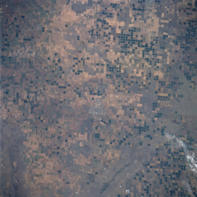 |
| STS078-736-68 Liberal Area, Kansas June, 1996 Numerous central pivot irrigation operations can be seen in this near-vertical view taken over southwestern Kansas and the panhandle of western Oklahoma. The small city of Liberal, Kansas, near the Kansas/Oklahoma border, is just to the right of the center of the image. The runways of the Liberal Municipal Airport, located just to the northwest of the city, are also visible. Liberal is the trade center for this grain and livestock area. Oil and natural gas are also extracted in the region. Liberal and the surrounding agricultural regions are located on the Ogallala Aquifer, a vast underground water supply that stretches across the Great Plains from southern South Dakota to the panhandle of northern Texas. It is the largest underground water supply in the United States. The level of the water table is falling because irrigation systems, such as these visible throughout the image, are depleting the water system faster than natural processes can replenish it. Eventually this situation may well cause an economic hardship throughout this region of the Great Plains within the next decade or so. |
| Images: | All Available Images Low-Resolution 367k |
|
| Mission: | STS078 |
|
| Roll - Frame: | 736 - 68 |
|
| Geographical Name: | USA-KANSAS |
|
| Features: | LIBERAL,PIVOT & DRY AGR. |
|
| Center Lat x Lon: | 37.0N x 101W |
|
| Film Exposure: | N | N=Normal exposure, U=Under exposed, O=Over exposed, F=out of Focus |
| Percentage of Cloud Cover-CLDP: | 0 |
|
| Camera:: | HB |
|
| Camera Tilt: | 17 | LO=Low Oblique, HO=High Oblique, NV=Near Vertical |
| Camera Focal Length: | 250 |
|
| Nadir to Photo Center Direction: | W | The direction from the nadir to the center point, N=North, S=South, E=East, W=West |
| Stereo?: | Y | Y=Yes there is an adjacent picture of the same area, N=No there isn't |
| Orbit Number: | 99 |
|
| Date: | 19960626 | YYYYMMDD |
| Time: | 174905 | GMT HHMMSS |
| Nadir Lat: | 36.8N |
Latitude of suborbital point of spacecraft |
| Nadir Lon: | 100.3W |
Longitude of suborbital point of spacecraft |
| Sun Azimuth: | 135 | Clockwise angle in degrees from north to the sun measured at the nadir point |
| Space Craft Altitude: | 144 | nautical miles |
| Sun Elevation: | 72 | Angle in degrees between the horizon and the sun, measured at the nadir point |
| Land Views: | PLAIN |
|
| Water Views: | |
|
| Atmosphere Views: | |
|
| Man Made Views: | AGRICULTURE, PIVOT IRRIGATION, URBAN AREA, AIRPORT |
|
| City Views: | |
|
Photo is not associated with any sequences | ||
| NASA Home Page |
JSC Home Page |
JSC Digital Image Collection |
Earth Science & Remote Sensing |
|
This service is provided by the International Space Station program and the JSC Earth Science & Remote Sensing Unit, ARES Division, Exploration Integration Science Directorate.

|