
Geographic Region: BOLIVIA
Feature: LAKE TITICACA, MOUNTAINS
|
Geographic Region: BOLIVIA Feature: LAKE TITICACA, MOUNTAINS |
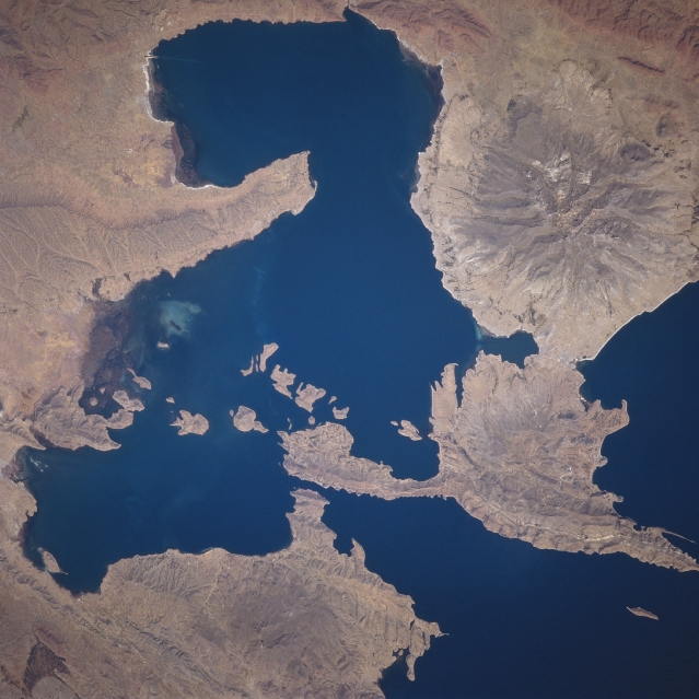 |
| STS078-735-033 Lake Titicaca, Bolivia and Peru June 1996 The dark water at the southeast end of Lake Titicaca contrasts dramatically with the rugged semi-desert in this detailed view of the area. The sparsely vegetated semiarid landscape helps to accentuate the topographic features that are found along the south shore of the lake. At least three eroded volcanic structures are visible; the largest one can be easily identified by the radial drainage pattern (western quadrant of the image). Maximum elevation of this volcano is 15718 feet (4790 meters) above sea level. The Strait of Tiguina connects the smaller southeast end of Lake Titicaca with the main part of the lake. Although the town of Copacabana, located along the northwest coast of the T-shaped peninsula, is not identifiable on this image, it is a site where Inca ruins can be visited. |
| Images: | All Available Images Low-Resolution 310k |
|
| Mission: | STS078 |
|
| Roll - Frame: | 735 - 33 |
|
| Geographical Name: | BOLIVIA |
|
| Features: | LAKE TITICACA, MOUNTAINS |
|
| Center Lat x Lon: | 16.5S x 69W |
|
| Film Exposure: | N | N=Normal exposure, U=Under exposed, O=Over exposed, F=out of Focus |
| Percentage of Cloud Cover-CLDP: | 0 |
|
| Camera:: | HB |
|
| Camera Tilt: | 16 | LO=Low Oblique, HO=High Oblique, NV=Near Vertical |
| Camera Focal Length: | 250 |
|
| Nadir to Photo Center Direction: | E | The direction from the nadir to the center point, N=North, S=South, E=East, W=West |
| Stereo?: | N | Y=Yes there is an adjacent picture of the same area, N=No there isn't |
| Orbit Number: | 227 |
|
| Date: | 19960704 | YYYYMMDD |
| Time: | 173326 | GMT HHMMSS |
| Nadir Lat: | 16.6S |
Latitude of suborbital point of spacecraft |
| Nadir Lon: | 69.7W |
Longitude of suborbital point of spacecraft |
| Sun Azimuth: | 342 | Clockwise angle in degrees from north to the sun measured at the nadir point |
| Space Craft Altitude: | 144 | nautical miles |
| Sun Elevation: | 49 | Angle in degrees between the horizon and the sun, measured at the nadir point |
| Land Views: | VOLCANO, MOUNTAIN |
|
| Water Views: | LAKE |
|
| Atmosphere Views: | |
|
| Man Made Views: | |
|
| City Views: | |
|
Photo is not associated with any sequences | ||
| NASA Home Page |
JSC Home Page |
JSC Digital Image Collection |
Earth Science & Remote Sensing |
|
This service is provided by the International Space Station program and the JSC Earth Science & Remote Sensing Unit, ARES Division, Exploration Integration Science Directorate.

|