
Geographic Region: MEXICO
Feature: SIERRA MADRE,MINE RUNOFF
|
Geographic Region: MEXICO Feature: SIERRA MADRE,MINE RUNOFF |
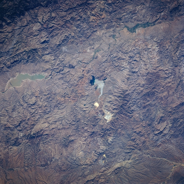 |
| STS078-735-20 Open Pit (Copper) Mine, Sonora, Mexico June 1996 The rugged, mountainous terrain of the Sierra Madre Occidental is evident in this near-nadir image of a section of northeastern Sonora State. The only three identifiable features are a reservoir, a river valley, and a large open pit-mining site. The Angostura Reservoir (opaque, elongated feature near the northern side of the image) is located in the river valley (north-south orientation) that is a tributary of the Yaqui River system. The highly reflective areas in the center of the picture is the "La Cardidad" open pit mine, that is located east of the small town of Nacozari (not identifiable on this small scale image). This mining site is one of the largest copper and molybdenum operations in the northwest Mexico. |
| Images: | All Available Images Low-Resolution 427k |
|
| Mission: | STS078 |
|
| Roll - Frame: | 735 - 20 |
|
| Geographical Name: | MEXICO |
|
| Features: | SIERRA MADRE,MINE RUNOFF |
|
| Center Lat x Lon: | 30.5N x 109.5W |
|
| Film Exposure: | N | N=Normal exposure, U=Under exposed, O=Over exposed, F=out of Focus |
| Percentage of Cloud Cover-CLDP: | 0 |
|
| Camera:: | HB |
|
| Camera Tilt: | 10 | LO=Low Oblique, HO=High Oblique, NV=Near Vertical |
| Camera Focal Length: | 100 |
|
| Nadir to Photo Center Direction: | W | The direction from the nadir to the center point, N=North, S=South, E=East, W=West |
| Stereo?: | Y | Y=Yes there is an adjacent picture of the same area, N=No there isn't |
| Orbit Number: | 226 |
|
| Date: | 19960704 | YYYYMMDD |
| Time: | 154355 | GMT HHMMSS |
| Nadir Lat: | 30.4N |
Latitude of suborbital point of spacecraft |
| Nadir Lon: | 109.1W |
Longitude of suborbital point of spacecraft |
| Sun Azimuth: | 85 | Clockwise angle in degrees from north to the sun measured at the nadir point |
| Space Craft Altitude: | 139 | nautical miles |
| Sun Elevation: | 41 | Angle in degrees between the horizon and the sun, measured at the nadir point |
| Land Views: | MOUNTAIN |
|
| Water Views: | RESERVOIR, RIVER |
|
| Atmosphere Views: | |
|
| Man Made Views: | MINING |
|
| City Views: | |
|
Photo is not associated with any sequences | ||
| NASA Home Page |
JSC Home Page |
JSC Digital Image Collection |
Earth Science & Remote Sensing |
|
This service is provided by the International Space Station program and the JSC Earth Science & Remote Sensing Unit, ARES Division, Exploration Integration Science Directorate.

|