
Geographic Region: USA-TEXAS
Feature: WICHITA FALLS,RED R.,AGR
|
Geographic Region: USA-TEXAS Feature: WICHITA FALLS,RED R.,AGR |
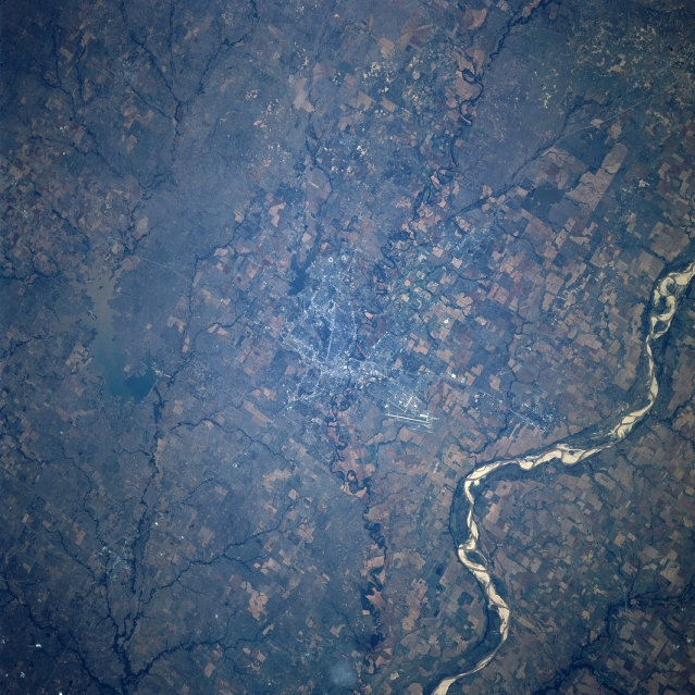 |
| STS078-734-007 Wichita Falls, Texas, USA June 1996 The urban area of Wichita Falls can be identified by the numerous intersecting roads and highways near the center of the image. A section of Interstate Highway 44 that extends northward from Wichita Falls to Lawton, Oklahoma, can be traced across the landscape, especially where the highway crosses the Red River. The combined runways of Sheppard Air Force Base and the Wichita Falls commercial airport are visible north of Wichita Falls. Large cultivated field patterns on both the Oklahoma (upper right) side and the Texas side of the Red River are visible. Several meandering tributary streams (dark, linear features) of the Red River are visible. Lake Arrowhead with a light-colored sediment plume in the southern section of the lake can be seen near the southern edge of the picture. A smaller, unnamed reservoir is also visible immediately southwest of Wichita Falls. |
| Images: | All Available Images Low-Resolution 373k |
|
| Mission: | STS078 |
|
| Roll - Frame: | 734 - 7 |
|
| Geographical Name: | USA-TEXAS |
|
| Features: | WICHITA FALLS,RED R.,AGR |
|
| Center Lat x Lon: | 34.0N x 98.5W |
|
| Film Exposure: | N | N=Normal exposure, U=Under exposed, O=Over exposed, F=out of Focus |
| Percentage of Cloud Cover-CLDP: | 0 |
|
| Camera:: | HB |
|
| Camera Tilt: | 24 | LO=Low Oblique, HO=High Oblique, NV=Near Vertical |
| Camera Focal Length: | 250 |
|
| Nadir to Photo Center Direction: | SE | The direction from the nadir to the center point, N=North, S=South, E=East, W=West |
| Stereo?: | N | Y=Yes there is an adjacent picture of the same area, N=No there isn't |
| Orbit Number: | 81 |
|
| Date: | 19960625 | YYYYMMDD |
| Time: | 144223 | GMT HHMMSS |
| Nadir Lat: | 34.9N |
Latitude of suborbital point of spacecraft |
| Nadir Lon: | 99.1W |
Longitude of suborbital point of spacecraft |
| Sun Azimuth: | 86 | Clockwise angle in degrees from north to the sun measured at the nadir point |
| Space Craft Altitude: | 144 | nautical miles |
| Sun Elevation: | 38 | Angle in degrees between the horizon and the sun, measured at the nadir point |
| Land Views: | PLAIN, FLOOD PLAIN |
|
| Water Views: | RIVER |
|
| Atmosphere Views: | |
|
| Man Made Views: | URBAN AREA, AIRPORT, AGRICULTURE |
|
| City Views: | |
|
Photo is not associated with any sequences | ||
| NASA Home Page |
JSC Home Page |
JSC Digital Image Collection |
Earth Science & Remote Sensing |
|
This service is provided by the International Space Station program and the JSC Earth Science & Remote Sensing Unit, ARES Division, Exploration Integration Science Directorate.

|