
Geographic Region: USA-KENTUCKY
Feature: NEW ALBANY, LOUISVILLE
|
Geographic Region: USA-KENTUCKY Feature: NEW ALBANY, LOUISVILLE |
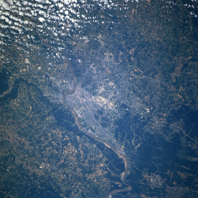 |
| STS078-734-023 Louisville, Kentucky, USA June 1996 Several bridges span the Ohio River, the narrow muddy-looking feature that extends across the image from northeast to southwest. Downtown Louisville is adjacent to the Ohio River just east of the rounded promontory that juts northward into the Ohio River (slightly right of center). Indiana is north of the river and Kentucky is south of the river. Major highways can be traced across the Louisville region. These roads include an inner loop or beltway (Interstate Highway 264) and an outer loop (Interstate Highway 265). Additionally, Interstate Highway 65, a major north-south artery, is especially easy to discern as it enters the south side of the city. A cluster of highly reflective features (center of the picture) shows the location of Standiford Field and a large federal installation. The darker landscape maps the extent of heavily wooded, rugged, undeveloped terrain, located southwest of the urban area. There is also a narrow band of wooded acreage along the north bank of the Ohio River west of Louisville. |
| Images: | All Available Images Low-Resolution 404k |
|
| Mission: | STS078 |
|
| Roll - Frame: | 734 - 23 |
|
| Geographical Name: | USA-KENTUCKY |
|
| Features: | NEW ALBANY, LOUISVILLE |
|
| Center Lat x Lon: | 38.0N x 86W |
|
| Film Exposure: | N | N=Normal exposure, U=Under exposed, O=Over exposed, F=out of Focus |
| Percentage of Cloud Cover-CLDP: | 10 |
|
| Camera:: | HB |
|
| Camera Tilt: | 39 | LO=Low Oblique, HO=High Oblique, NV=Near Vertical |
| Camera Focal Length: | 250 |
|
| Nadir to Photo Center Direction: | W | The direction from the nadir to the center point, N=North, S=South, E=East, W=West |
| Stereo?: | N | Y=Yes there is an adjacent picture of the same area, N=No there isn't |
| Orbit Number: | 81 |
|
| Date: | 19960625 | YYYYMMDD |
| Time: | 144540 | GMT HHMMSS |
| Nadir Lat: | 38.2N |
Latitude of suborbital point of spacecraft |
| Nadir Lon: | 84.1W |
Longitude of suborbital point of spacecraft |
| Sun Azimuth: | 99 | Clockwise angle in degrees from north to the sun measured at the nadir point |
| Space Craft Altitude: | 144 | nautical miles |
| Sun Elevation: | 50 | Angle in degrees between the horizon and the sun, measured at the nadir point |
| Land Views: | FOREST, HILL |
|
| Water Views: | RIVER |
|
| Atmosphere Views: | |
|
| Man Made Views: | HIGHWAY, URBAN AREA |
|
| City Views: | |
|
Photo is not associated with any sequences | ||
| NASA Home Page |
JSC Home Page |
JSC Digital Image Collection |
Earth Science & Remote Sensing |
|
This service is provided by the International Space Station program and the JSC Earth Science & Remote Sensing Unit, ARES Division, Exploration Integration Science Directorate.

|