
Geographic Region: IRAN
Feature: NORTHERN END PERSIAN G.
|
Geographic Region: IRAN Feature: NORTHERN END PERSIAN G. |
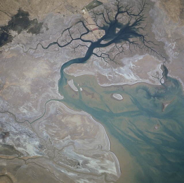 |
| STS078-732-088 Karun River Delta, Iran June 1996 The Karun River, along with Tigris and Euphrates Rivers immediately west of this area, has formed a broad deltaic plain at the northern end of the Persian (Arabian) Gulf. This section of coastal plain is located in the southwest corner of Iran and includes sandy beaches, intertidal flats, and small estuaries. Large quantities of sand and silt are deposited at the mouths of the distributary channels (darker, meandering features upper half of the image) of the Karun River. Except for the deeper channels (darker blues), the coastal waters appear to be shallow with extensive sandbars (tannish-looking features) and a few islands. The darker water inlet (near bottom center) displays an intricate drainage pattern. The Iranian port city of Bandar-e Khomeyni is situated along the northern edge of this inland harbor. The straight, linear features (lower right corner) are highway and pipeline right of ways. |
| Images: | All Available Images Low-Resolution 340k |
|
| Mission: | STS078 |
|
| Roll - Frame: | 732 - 88 |
|
| Geographical Name: | IRAN |
|
| Features: | NORTHERN END PERSIAN G. |
|
| Center Lat x Lon: | 30.5N x 49.0E |
|
| Film Exposure: | N | N=Normal exposure, U=Under exposed, O=Over exposed, F=out of Focus |
| Percentage of Cloud Cover-CLDP: | 0 |
|
| Camera:: | HB |
|
| Camera Tilt: | 18 | LO=Low Oblique, HO=High Oblique, NV=Near Vertical |
| Camera Focal Length: | 250 |
|
| Nadir to Photo Center Direction: | N | The direction from the nadir to the center point, N=North, S=South, E=East, W=West |
| Stereo?: | Y | Y=Yes there is an adjacent picture of the same area, N=No there isn't |
| Orbit Number: | 62 |
|
| Date: | 19960624 | YYYYMMDD |
| Time: | 103232 | GMT HHMMSS |
| Nadir Lat: | 29.7N |
Latitude of suborbital point of spacecraft |
| Nadir Lon: | 49.0E |
Longitude of suborbital point of spacecraft |
| Sun Azimuth: | 262 | Clockwise angle in degrees from north to the sun measured at the nadir point |
| Space Craft Altitude: | 146 | nautical miles |
| Sun Elevation: | 66 | Angle in degrees between the horizon and the sun, measured at the nadir point |
| Land Views: | PLAIN |
|
| Water Views: | RIVER, DELTA, GULF |
|
| Atmosphere Views: | |
|
| Man Made Views: | |
|
| City Views: | |
|
Photo is not associated with any sequences | ||
| NASA Home Page |
JSC Home Page |
JSC Digital Image Collection |
Earth Science & Remote Sensing |
|
This service is provided by the International Space Station program and the JSC Earth Science & Remote Sensing Unit, ARES Division, Exploration Integration Science Directorate.

|