
Geographic Region: TURKEY
Feature: IZMIR BAY, COAST, AGR.
|
Geographic Region: TURKEY Feature: IZMIR BAY, COAST, AGR. |
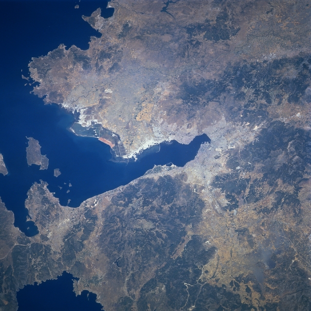 |
| STS078-732-056 Gulf of Izmir, Izmir, Turkey June 1996 The seaport city of Izmir (just right of the center of the image), the third largest city in Turkey, and the country's most important port in Asia, can be seen in this north-looking view. Izmir is an important commercial and industrial center, whose manufacturers include paper, metal goods, dyes, textiles, processed food, and tobacco. The city is located in one of the richest agricultural regions in Turkey. The expanding city ascends the gentle slopes that encircle it. It is a major transportation hub with lines extending outward to all sections of the country. Izmir was nearly destroyed by fire in September 1922. Izmir was badly damaged by earthquakes in 1928 and again in 1939. The Gulf of Izmir, an arm of the Aegean Sea, extends westward or left from near the center of the image to the left center of the image. |
| Images: | All Available Images Low-Resolution 358k |
|
| Mission: | STS078 |
|
| Roll - Frame: | 732 - 56 |
|
| Geographical Name: | TURKEY |
|
| Features: | IZMIR BAY, COAST, AGR. |
|
| Center Lat x Lon: | 38.5N x 27.0E |
|
| Film Exposure: | N | N=Normal exposure, U=Under exposed, O=Over exposed, F=out of Focus |
| Percentage of Cloud Cover-CLDP: | 0 |
|
| Camera:: | HB |
|
| Camera Tilt: | 32 | LO=Low Oblique, HO=High Oblique, NV=Near Vertical |
| Camera Focal Length: | 250 |
|
| Nadir to Photo Center Direction: | N | The direction from the nadir to the center point, N=North, S=South, E=East, W=West |
| Stereo?: | N | Y=Yes there is an adjacent picture of the same area, N=No there isn't |
| Orbit Number: | 62 |
|
| Date: | 19960624 | YYYYMMDD |
| Time: | 102722 | GMT HHMMSS |
| Nadir Lat: | 37.0N |
Latitude of suborbital point of spacecraft |
| Nadir Lon: | 27.1E |
Longitude of suborbital point of spacecraft |
| Sun Azimuth: | 193 | Clockwise angle in degrees from north to the sun measured at the nadir point |
| Space Craft Altitude: | 145 | nautical miles |
| Sun Elevation: | 76 | Angle in degrees between the horizon and the sun, measured at the nadir point |
| Land Views: | MOUNTAIN, COAST |
|
| Water Views: | GULF, RIVER |
|
| Atmosphere Views: | |
|
| Man Made Views: | URBAN AREA |
|
| City Views: | IZMIR |
|
Photo is not associated with any sequences | ||
| NASA Home Page |
JSC Home Page |
JSC Digital Image Collection |
Earth Science & Remote Sensing |
|
This service is provided by the International Space Station program and the JSC Earth Science & Remote Sensing Unit, ARES Division, Exploration Integration Science Directorate.

|