Geographic Region: INDONESIA-B
Feature: BARITO RIVER, SED. PLUME
|
Geographic Region: INDONESIA-B Feature: BARITO RIVER, SED. PLUME |
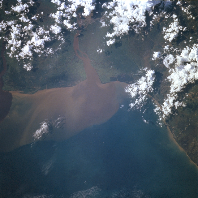 |
| STS078-727-021 Barito River, South Kalimantan, Indonesia June 1996 A sizeable sediment plume (lighter-colored water center of image) from the Barito River can be seen entering the Java Sea along the southeast coast of Borneo. This region is more accurately called South Kalimantan, one of four provinces of Indonesia that is located in Kalimantan (formerly Borneo). Bandjermasin, the capital city and center of trade for South Kalimantan province, is partially visible between the clouds and their shadows (top center) along the east side of the Barito River. The Barito River is the largest river in Indonesia. Although the coastal plains are swampy wetlands in this rainforest environment, large sections of land are being cleared for plantation and sedentary agriculture north of Bandjermasin along the Barito River. |
| Images: | All Available Images Low-Resolution 328k |
|
| Mission: | STS078 |
|
| Roll - Frame: | 727 - 21 |
|
| Geographical Name: | INDONESIA-B |
|
| Features: | BARITO RIVER, SED. PLUME |
|
| Center Lat x Lon: | 3.5S x 114.5E |
|
| Film Exposure: | N | N=Normal exposure, U=Under exposed, O=Over exposed, F=out of Focus |
| Percentage of Cloud Cover-CLDP: | 20 |
|
| Camera:: | HB |
|
| Camera Tilt: | LO | LO=Low Oblique, HO=High Oblique, NV=Near Vertical |
| Camera Focal Length: | 100 |
|
| Nadir to Photo Center Direction: | The direction from the nadir to the center point, N=North, S=South, E=East, W=West |
|
| Stereo?: | N | Y=Yes there is an adjacent picture of the same area, N=No there isn't |
| Orbit Number: | |
|
| Date: | 1996____ | YYYYMMDD |
| Time: | GMT HHMMSS |
|
| Nadir Lat: | N |
Latitude of suborbital point of spacecraft |
| Nadir Lon: | E |
Longitude of suborbital point of spacecraft |
| Sun Azimuth: | Clockwise angle in degrees from north to the sun measured at the nadir point |
|
| Space Craft Altitude: | nautical miles |
|
| Sun Elevation: | Angle in degrees between the horizon and the sun, measured at the nadir point |
|
| Land Views: | PLAIN |
|
| Water Views: | RIVER, SEDIMENT |
|
| Atmosphere Views: | |
|
| Man Made Views: | |
|
| City Views: | |
|
Photo is not associated with any sequences | ||
| NASA Home Page |
JSC Home Page |
JSC Digital Image Collection |
Earth Science & Remote Sensing |
|
This service is provided by the International Space Station program and the JSC Earth Science & Remote Sensing Unit, ARES Division, Exploration Integration Science Directorate.

|